
Wednesday night: Humid. Warm. Low: 72. Thursday: Partly cloudy. Hot and humid. High: 91. Friday: Scattered rain. High: 89.
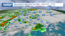
Showers and storms became more numerous across New England Wednesday, though we have plenty of dry parts of the day, too.
The concern with these storms will be from heavy rainfall leading to flash flooding in localized areas. The atmosphere is pretty water loaded, as we can tell from the high humidity.
WATCH ANYTIME FOR FREE
Stream NBC10 Boston news for free, 24/7, wherever you are. |
Flash flood warnings were in place late Wednesday in parts of Maine, New Hampshire and Vermont, but have since expired.
See all severe weather alerts in your area here, and track live radar below.
Get updates on what's happening in Boston to your inbox. Sign up for our News Headlines newsletter.
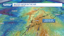
In the upper levels of the atmosphere, we are also getting a straight transport of water vapor from the southern Atlantic Ocean. So, any shower or storm will be efficient at squeezing out tons of rainfall. Just like a wet sponge.
The non-severe rain showers could give us 1 to 2 inches rain rates per hour. And we don't expect any severe storms in terms of damaging wind, hail or tornadoes. These are your garden-variety t-showers that could produce some lightning, but mostly torrential rain.

As the rain tapers Wednesday night, we stay muggy with lows in the 70s. Then, here comes the real heat for the week. Highs return to the low 90s for Thursday and Friday as the humidity remains high.
Heat index numbers reach the mid to upper 90s both days, too. And our shower or pop-up storm chance remains pretty low, but it does still exist.
We see more widespread shower and storms this weekend with highs in the 80s and no break in the humidity.