
Hot and humid weather takes over New England, with Thursday becoming the hottest day, as heat indices may reach 100 degrees. There may be some late afternoon showers or thunderstorms in western New England on Thursday and Friday, but overall, the week is expected to remain mainly dry.
The weekend and early next week will remain warm and humid, with more clouds and the possibility of scattered showers and thunderstorms, which will dip our temperatures. Heat advisories are in effect for inland areas but these advisories may be extended through Friday.

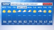
Highs across New England Wednesday reach the lower 90s, but heat indices may range up to the mid-90s. Overnight, temperatures will remain muggy with patchy fog in typical fog-prone areas. On Thursday, temperatures will be in the low to mid-90s in most of southern New England, with heat indices in the mid to upper 90s due to high humidity and as high as 100 at the warmest spots. Some scattered showers and thunderstorms are possible in the western areas during the afternoon, driven by instability and potential weak short-wave disturbances.
Get Boston local news, weather forecasts, lifestyle and entertainment stories to your inbox. Sign up for NBC Boston’s newsletters.
In the long term, Friday will still be hot and humid, with a chance of diurnally driven showers and thunderstorms mainly in the far western and northern areas. The weekend and early next week will see the continuation of humid conditions with the potential for scattered showers and thunderstorms, but the timing remains uncertain.
High temperatures will be in the upper 70s to middle 80s due to increased cloud cover and rain. There may be a risk of excessive rainfall and flooding in localized areas, so it's important to monitor the weather closely during this period.
