A quick burst of overnight snow totaled as much as two and a half inches for some parts of central Massachusetts with a coating more commonplace before a change to rain that delivered a wet and slow morning commute.
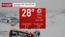
Meanwhile, northern New England continues to see snow – both in the North Country and with elevation, where highest snow amounts of six to 12 inches will be recorded, bringing a great boon for ski resorts in Vermont, New Hampshire and Maine while sparing most of the higher population centers at lower elevation.
Regardless of wet or white, precipitation tapers Wednesday afternoon as a drying west wind takes hold, sweeping away the briefly mild air over eastern New England and dropping temperatures from an afternoon high in the 50s and 60s, through the 40s by late day and either side of 30 degrees overnight Wednesday night.
Get Boston local news, weather forecasts, lifestyle and entertainment stories to your inbox. Sign up for NBC Boston’s newsletters.
While southern New England roads will dry before dropping below freezing, some northern New England roads will likely see patchy black ice Wednesday night into Thursday morning.
Although the stretch from Thursday through Saturday brings fair and cool weather, overall there is an energetic disturbance riding overhead Thursday that will result in building clouds blotting out morning sun, and some of those clouds will yield snow flurries and rain sprinkles here and there during the afternoon.
Friday and Saturday are less likely to deliver any flakes or drops with enough dry air to keep skies fair and enough cool air to hold high temperatures in the lower to middle 40s south and 30s north.
Another disturbance nearby on Sunday increases clouds and raises the chance of scattered rain and snow showers briefly before another installment of fair, cool and dry weather in the busy travel days leading up to Thanksgiving.
Not everyone in the country will have quiet pre-holiday weather, however, with Wednesday rain and snow in the Pacific Northwest expected, and another storm taking shape from the Central and Southern Plains through the Lower Mississippi River Valley into the Southeast. It’s this storm that will pull north on Thanksgiving Day, likely arriving to New England with rain by day’s end or nightfall, lasting into Black Friday.
It’s early to say whether any of that rain could fall as snow in the northern mountains, but regardless, most ski areas will be able to blast lots of manmade snow with cold nights ahead after the boost in natural snow.