
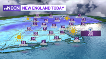
Though the air temperatures are very cold on Tuesday, it is certainly nice to see the sun out there! Grab those sunglasses, as solar glare may be an issue driving with the low sun angle, especially during the evening commute!
Highs will be in the 20s north and 30s south. Clouds will be on the increase Tuesday night, with temperatures dropping into the 20s south and teens north, rising slightly late as winds turn more southerly.
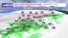
A weak system will pass through the region Wednesday, bringing mostly rain showers south. However, with cold air in place, we could see a bit of sleet and freezing rain at the onset, especially inland, but by the mid-morning, temperatures should be above freezing as milder air flows into the region.
Get Boston local news, weather forecasts, lifestyle and entertainment stories to your inbox. Sign up for NBC Boston’s newsletters.
Central and northern New England will see rain and snow showers much of the day as colder air holds on, but we're not expecting much in the way of accumulations. Highs reach the mid 40s to 50 south and 30s north.
Colder air moves back in Wednesday night with clearing skies behind a cold front, which will bring seasonable and dry conditions to the region on Thursday.
All eyes are on Friday, when we could see our first snow storm in the City of Boston! There are still some details to work out, but confidence is growing in a plowable amount of snow for the area, which is why we have a First Alert stamp on our exclusive 10-Day Forecast.
