
We have two more mild days ahead before winter returns in full swing.
After a spring feeling day Saturday, Sunday will be mild and dry with highs in the upper 40s and low 50s, under partly sunny skies.
Monday is also looking mild and a touch cooler with highs in the 40s and a light westerly wind.
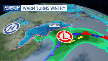
All eyes are on our next storm, though, as this pattern will flip quickly by Tuesday early morning.
Get Boston local news, weather forecasts, lifestyle and entertainment stories to your inbox. Sign up for NBC Boston’s newsletters.
When will it start snowing?
Southern New England will start to see impacts from a strong coastal low overnight Monday into Tuesday. Beginning as a rain-snow mix for the coast with interior southern New England getting in on all snow from the start.
Local
In-depth news coverage of the Greater Boston Area.


Everyone can anticipate snow by sunrise Tuesday. Moderate steady snowfall will continue through the morning. The heaviest bursts of snow will likely be in the early afternoon, with the intensity lightening up by the evening.
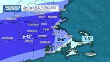
How much snow will we get?
Other impacts
Travel conditions for the morning commute Tuesday will be less than ideal with the potential for slick roads and reduced visibility.
The timing of this storm lines up with astronomical high tide and could bring minor coastal flooding near 2 p.m. Tuesday as high tide will be paired with a 2-3 foot surge along the coast.

Beyond Tuesday, the rest of the week is looking chilly. Highs in the 30s, lows in the low to mid 20s. Wednesday and Thursday will be mainly dry.
By Friday a few showers and snow showers are possible. With a dry and chilly weekend in store next weekend.
