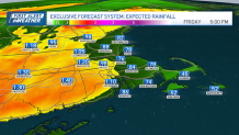
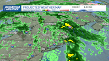
Our next First Alert is overnight Thursday into Friday through midday as a cold front moves through New England. Widespread heavy rain will bring in around 1 inch of rainfall accumulation across all of the northeast throughout the day.
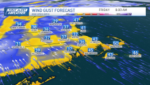
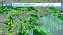
The majority of the rain will be from 10 p.m. Thursday to 9 a.m. Friday. The heaviest rain also coincides with the strongest winds from this system. Gusts will be from the south at 40-50 mph at the coasts, Cape and islands.
Get Boston local news, weather forecasts, lifestyle and entertainment stories to your inbox. Sign up for NBC Boston’s newsletters.
This will make the Friday morning commute slow-going, as there will be lots of standing water and ponding. A couple of thunderstorms are in the forecast on Friday as well, and in the afternoon if we can get some brief clearing, pop up storms are possible with another round of some showers by sunset.
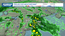
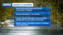
Our flood threat will be increased a bit from the heavy rainfall since streams and river beds are pretty full. Plus, the warm temps and rain will lead to lots of snowmelt across northern New England and the mountains. So we anticipate some rivers going to minor flood stage by the weekend.
Improving and drying weather returns for the weekend and as we head into Marathon Monday, with highs by that day nearing 70.
Local
In-depth news coverage of the Greater Boston Area.