
A massive storm system impacting much of the eastern United States will bring some welcome rain to New England Thursday afternoon, then to snow overnight, then to springtime for the weekend.
At the same time Thursday and Thursday night, we have low pressure passing south of New England and we have a cold front coming into northern New England.
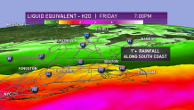
As precipitation begins in the afternoon it will start as rain, becoming heavy in southern New England Thursday evening, then changing from rain to snow in the middle of the night on the back edge from southern New Hampshire to the south coast of New England between midnight and sunrise.
Get Boston local news, weather forecasts, lifestyle and entertainment stories to your inbox. Sign up for NBC Boston’s newsletters.
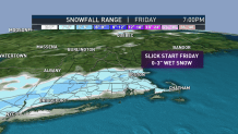
Rainfall amounts in excess of 1 inch are likely from Connecticut to Cape Cod and the Islands. Snowfall amounts of 1 to 3 inches are likely just north of the coastline and especially the hills of central and southern New England.
Places like Wachusett and/or Blue Hill may come in with 3 to 5 inches of snow, while downtown Boston has very little accumulation on pavement and cement.
More rural areas -- especially those with higher elevation -- may have snowy roads for a time late Thursday night and early Friday morning.
The sun will come out immediately in northern New England on Friday, and then gradually in southern New England through the morning. We all get a sunny afternoon Friday, with the temperature recovering to about 35 to 40 degrees.
There is a storm warning along the coast near Cape Cod for wind gusting past 50 miles an hour late tonight and first thing tomorrow morning.
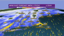
Further inland it will be breezy but not damaging.
Local
In-depth news coverage of the Greater Boston Area.


A powerful high-pressure system will move in from Canada over the weekend, bringing sunshine and initially very cold air. The temperature Friday night under a big bright moon will fall into the teens and low 20s. Plenty of sunshine for Saturday with a high temperature in the 30s to 40s north and 40s to low 50s south.
The vernal equinox is Saturday morning. At that time it will be freezing cold. But by Sunday afternoon with sunshine we should be back up to near 60 degrees away from the coast.
Next week we'll be monitoring another weather system off the middle Atlantic states that should stay south of New England but may induce a sea breeze for many of us.
It looks like a nice stretch of mild springtime weather until maybe the next chance of rain around Thursday or so, as seen in our First Alert 10-Day Forecast.
