
Widespread showers have taken over much of New England on Thursday evening as an upper level low slowly moves east. The exception is northern and eastern Maine where clouds are on the increase.
Our team of meteorologists have issued a First Alert for Friday because there is a new storm center developing off the coast of New Jersey on Thursday and it is going to intensify rapidly Thursday night, bringing heavy rain to portions of New England for most of the night.
WATCH ANYTIME FOR FREE
Stream NBC10 Boston news for free, 24/7, wherever you are. |
At the same time, air up in the sky is becoming colder, and we have rain changing to snow before midnight in the mountains of western New England. The snow level is going to come down in elevation, perhaps all the way to the valley floors by morning.
Get updates on what's happening in Boston to your inbox. Sign up for our News Headlines newsletter.
It will be a slippery morning commute for many, so you will have to plan accordingly.
Right now, it's nearly impossible to try and predict where the rain/snow line is going to end up on Friday. The ocean water temperature is in the 40s and with wind coming off the water gusting past 40 mph from the northeast it will make it challenging to get cold enough for snow anywhere near the coast. However, as the wind transitions to the north, colder air may penetrate all the way to the Boston area. There is the possibility for some coastal erosion due to high tide as well.
The confidence is high that we will get a serious elevation snowstorm. Portions of the Berkshires, the Green Mountains, and the Mount Monadnock area of New Hampshire are looking at double digit snowfall. It is a heavy, wet snow and leaves are coming out on the trees, so we are going to have power outages.
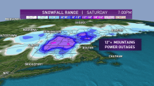
Once we get down in elevation to about 500 to 1,000 feet, we may see 6 inches plus of heavy wet snow, also capable of causing branches to break and power outages, even in some lower elevations. If you usually park under a tree, it will be a good idea if you store your car in the garage or somewhere else on Thursday night.
Local
In-depth news coverage of the Greater Boston Area.


This area of low pressure is going to move to Cape Cod and then stall during the day Friday, keeping the precipitation going for many through the day, and even into Saturday morning. With the center of the storm over Massachusetts Bay, the wind may come from the southwest on Cape Cod, pushing the temperature into the 50s with the possibility of a little sunshine Friday.
Overall, rainfall amounts in excess of 1 inch should be widespread, with even a few spots picking up close to 2.5 inches. This is beneficial rain for the region.
The weekend doesn’t look too promising -- a chance of a wintry mix in the morning Saturday with lots of clouds lingering through the day. Sunday will start off dry and then there is a chance for afternoon showers.
Stay tuned to our First Alert 10-day forecast for the latest updates.