
The front that caused all of the severe weather and crazy lightning Wednesday has stalled over New England, and we are getting more rain Thursday as heat and humidity only gradually subsides.
With a few hours of sunshine along the South Coast Thursday, that’s where we have destabilize the atmosphere most, and it’s just along and north of that area we have the heaviest rain Thursday afternoon and evening.
Torrential downpours are traversing mostly southern New England from west to east, with embedded strong to severe thunderstorms also possible. The showers may move fast enough to prevent flash flooding, but some communities may get one after another heavy downpour -- that’s called training, and for that reason we have some flash flood warning potential through the overnight.
Temperatures did cool Thursday, with highs in the 70s north and 80s south to near 90 degrees on Cape Cod.
Get Boston local news, weather forecasts, lifestyle and entertainment stories to your inbox. Sign up for NBC Boston’s newsletters.
Waves of low pressure continue to develop on the front as it slowly settles off to the south and east. That means periods of rain with possible thunder continuing through Friday, though the thunder threat probably moves out with the warmth by Friday morning.
Much colder air is on the way in for Friday, with high temperatures generally in the 60s, a little warmer well west and north where perhaps we get a break of sunshine. Otherwise, showers continue in a more scattered fashion Friday afternoon. Wind will likely come from the northeast at 10 to 20 miles an hour.
Weather Stories


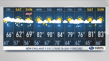
Though it does not look anywhere near as cold as Memorial Day weekend, the outlook is rather unfortunate, as so many of us have outdoor plans for Independence Day weekend. Any fireworks Thursday night may be very wet, Friday night a little less wet, and Saturday night a little less than that. It looks like Sunday afternoon and Monday have the best chances for good views, though even on Sunday we still have some showers around.
Temperatures are mostly in the 60s, 50s at night. Monday looks good, though, with sunshine and temperatures getting back up to 80 degrees. We are also tracking newly formed tropical storm Elsa, the earliest fifth named storm on record, heading toward the Caribbean with 45 mph winds Thursday evening, which may be south of New England late next week if it holds together. Stay tuned to our very busy First Alert 10-day forecast for the latest.
Sign up for our Breaking newsletter to get the most urgent news stories in your inbox.
