
Tuesday was an amazing day across New England, with high temperatures reaching the upper 60s to low 70s in southern areas and the 60s across much of the north.
Unfortunately we know that these exceptionally mild (or should I say warm?) temperatures for November wouldn’t last long, and that’s exactly what is expected as we look ahead to this week’s weather forecast. Although it will eventually cool off, we’ll do it in a couple of steps as we head into the weekend.
Get Boston local news, weather forecasts, lifestyle and entertainment stories to your inbox. Sign up for NBC Boston’s newsletters.
A cold front will slide through the region overnight, bringing with it some clouds and a few showers. The best chance for widespread shower activity will be across central and northern New England.
A few showers will sneak into southern areas by the morning, but should exit during the early morning hours, along with the clouds. The last to clear will be north/central and Downeast Maine, where we’re expecting clouds and showers to hold on through the early afternoon hours Wednesday, with improving conditions thereafter.
Local
In-depth news coverage of the Greater Boston Area.

The rest of the region will be mostly sunny and mild, with a bit of a breeze out of the west.
Lows Tuesday night will be in the 40s south, 30s to around 40 north. Highs Wednesday will be around 60 south, 50s north.
Veteran’s Day will feature close-to-average temperatures, with highs in the 50s south, upper 40s to around 50 north, and clouds increasing during the day.
Our main focus will be Friday, when a strong storm system exits the Great Lakes region and pushes through New England during the day and into Friday night.
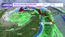
Our biggest concern will be locally heavy rain in the afternoon and evening along with gusty winds, especially along the coast.
Rain amounts look to be between 1-1.5 inches when all is said and done, which could cause some localized flooding and ponding on the roadways during the evening commute, especially where there is poor drainage.
Our weather team has issued a First Alert for Friday and will continue to keep you updated as more details come our way.
As we peek into the weekend, the trend is cooler and drier, though a shower can’t be ruled out, especially as we close out the weekend late Sunday. It also looks cold enough across the higher terrain in northern areas to bring some snow showers as well!
