
The passage of a sharp, well-defined cold front Friday morning not only meant a shift in the wind to blow from the northwest, but also an end to the record warmth.
The cold returns
Replacing the mild air is a more classic, seasonable winter air that’s been sending temperatures down even beneath sunshine Friday, with wind chill values poised to dip into the teens overnight Friday night under clear skies with a fresh breeze. Over the next several days, the wind will be a nearly constant factor as air changes over regularly in New England.
Get Boston local news, weather forecasts, lifestyle and entertainment stories to your inbox. Sign up for NBC Boston’s newsletters.
Storm moves through Saturday
Saturday is a prime example of changing air and a busy breeze, as an energetic disturbance aloft prompts weak storm development over Northern New England at ground level, cranking up the southwest breeze for much of New England and driving blossoming snow showers into New England from west to east Saturday morning to midday, continuing off and on through the afternoon. Moisture is limited with this system, so snowfall amounts will be limited, as well, with a coating to an inch probable for interior Southern New England with a bit more in the Berkshires and a coating to as much as three or four inches in the North Country, mostly with high terrain picking up the most snow, though the Crown of Maine may see higher amounts.
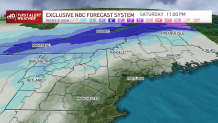
For most of New England, Saturday high temperatures in the 30s will inhibit snow from sticking to the roads, but colder surfaces will accumulate snow more readily in the cold air, and mountain roads in the north will be more prone to become snow-covered. As the system zips along Saturday evening, the sky clears but the wind stays busy behind a weak cold front that will reinforce the winter chill regionwide for Sunday, though the dry nature of that new, chilly air will mean a fair sky.
Local
In-depth news coverage of the Greater Boston Area.


More mild temps to start the week
The prevailing weather pattern in the Lower 48 states is mild heading into the start of next week – our cold weekend air really is a relatively small pocket with respect to the country and for that reason it will be pretty quick to relent, with a milder breeze Monday pushing high temperatures to either side of 50 degrees.
A couple of disturbances take aim at New England next week – one with rain on Tuesday, then a shot of cooler and drier air will take hold Wednesday and Thursday but set the stage for the possibility of a wintry mix, at least for some of New England, Thursday night into Friday. At this point, the early call on next weekend looks fair and cool behind the departing late-week system.
