
Wednesday: Partly Cloudy. Humid Wind: SW 5-15mph. High: 85.
Overnight Wednesday night: Cloudy. Warm. Low: 63.
Thursday: Morning Downpours. Isolated Thunder. High: 72.
Friday: Scattered Afternoon Rain. High: 75.
This is the last stand of dry weather, and we're going out with a bang. Highs soar to the mid and upper 80s under a partly sunny sky. In a sign of things to come, storms may fire this afternoon.
A little blob of unstable air in the upper atmosphere is to blame/thank for this threat but larger, more complex storm system will arrive Thursday.
WATCH ANYTIME FOR FREE
Stream NBC10 Boston news for free, 24/7, wherever you are. |
We'll sink from our perch of 80s back down to the low 70s as the showers move through from time to time.
Get updates on what's happening in Boston to your inbox. Sign up for our News Headlines newsletter.
This storm will be the seminal event to change the pattern for the next 7 to 10 days. For all that, you'd think we'd see flooding rain or an outbreak of severe weather. But this storm is subtle, and it will take some time for it to morph the jet stream above us.
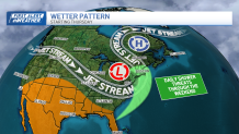
What is evolving is what is known as a block. This block will do exactly what it sounds like: jam weather systems in the jet stream. That means very little will change over the next several days. Yes, the sun will return as early as Friday in some spots, but whatever sun we see in this unsettled pattern will only help to support the development of more showers. Same goes for the weekend.
Temperatures hover in the low to mid-70s into early next week. Timing and placement of the showers is a fool's errand in this kind of setup.

More often than not, we'll unravel those mysteries on the day of the forecast.