The holiday weekend is in full swing, and this time of year, or any high-traffic week, I’m often asked, "Should I leave early?"
Without hesitation, the answer is always yes. While it may mean more time spent with your in-laws and distant cousins, it reduces the risk of something going wrong.
WATCH ANYTIME FOR FREE
Stream NBC10 Boston news for free, 24/7, wherever you are. |
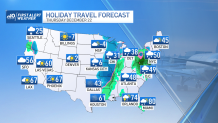
A major winter storm is in the works and it will impact major airport hubs across the Midwest, southern U.S., Central Plains, Southeast and Eastern Seaboard. Ground stops and ground delays will likely be issued across the entire country.
For travel, the bottom line is this: The earlier the better — or plan on traveling late. For example, if your flight on Thursday is canceled, you may not be able to rebook until late Friday or even Saturday, as the weather settles on Christmas Eve.
Get updates on what's happening in Boston to your inbox. Sign up for our News Headlines newsletter.
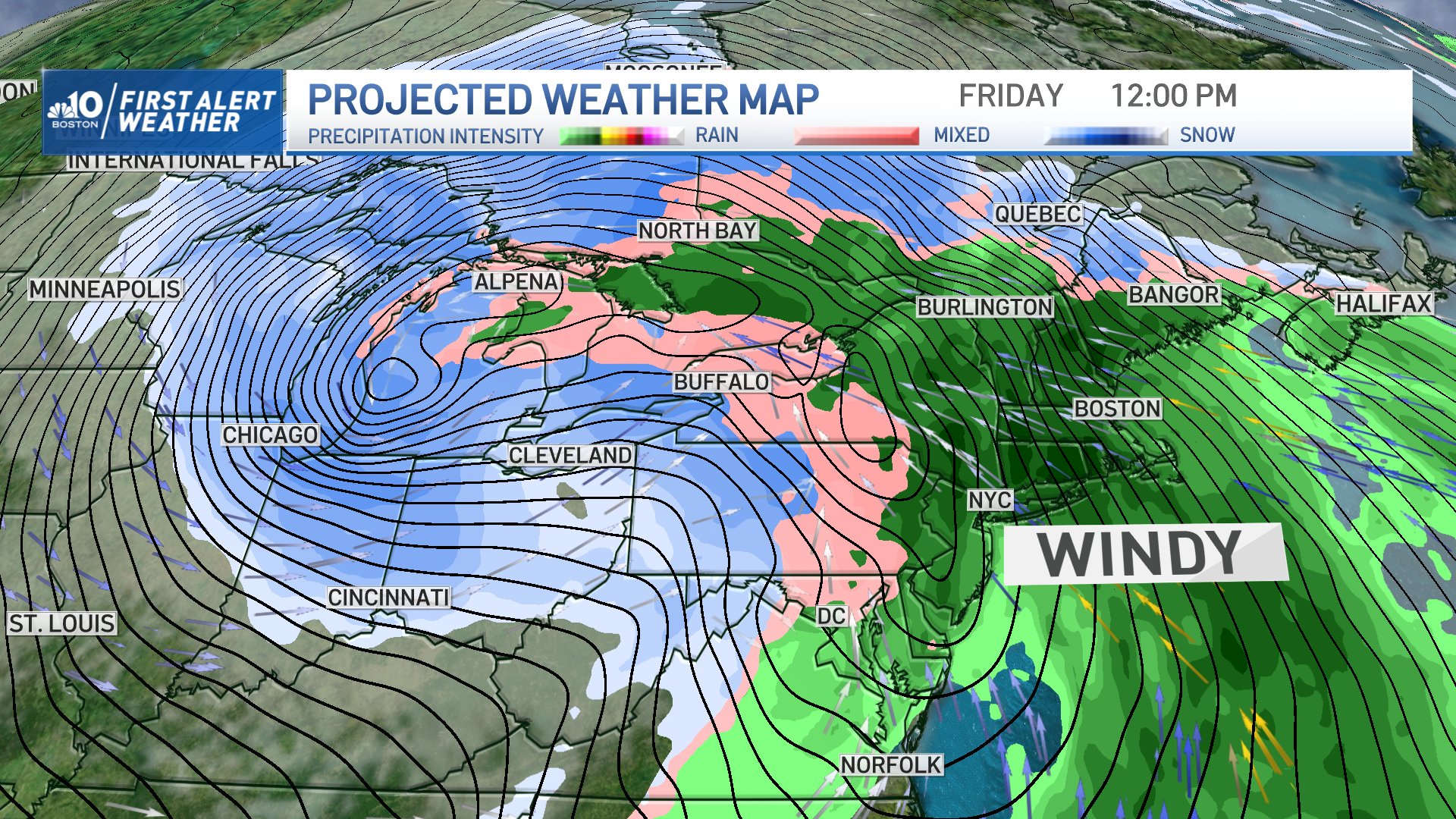
Bomb cyclone forms
As an Arctic airmass looms over the Dakotas Wednesday and spreads into the upper Midwest and Central Plains, dangerous wind chills below zero will stretch as far south as Arkansas and North Texas.
Pressure will drop at the center of this massive storm system, causing it to undergo a process called bombogenesis — making this system what some people call a "bomb cyclone."
The forecasted central pressure Thursday morning is near 1011 mb and is forecasted to drop to 978 mb in a 24-hour period. In response to the drop in pressure, winds substantially pick up. However, the low-pressure center of the storm isn't forecasted to strike the Boston area.
With this push of cold air, blizzard and near-blizzard conditions will stretch across the Dakotas and through the Midwest, impacting airports in the Twin Cities, Chicago, St. Louis, Detroit and Cincinnati. Technically, in blizzard conditions, winds are 35 miles an hour for three hours at a time, as visibility is reduced to a quarter of a mile or less.
Not only will airports see a substantial drop in visibility, but the conditions could impact major roadways along Interstate 90 in southern Minnesota, as snow starts to fall Wednesday afternoon and clears Thursday midday. I-29 in Western Iowa will get a blowing snow Wednesday evening, and snow will fall along I-49 from Kansas City to Bentonville, Arkansas, Thursday morning, clearing late evening.
As the storm moves over Chicagoland, conditions likely go downhill, with snow arriving Thursday afternoon and not stopping until Friday night.
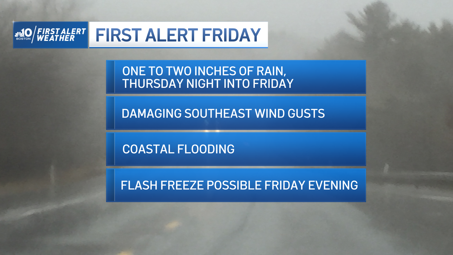
As for the impacts in New England, we’re expecting strong winds and driving rains Friday. Wind gusts along the Mass. Pike will range from 45-55 miles per hour.
Storm impacts on flights at Boston Logan and beyond
Forecasting airport delays is a tricky game — sometimes trickier than actually forecasting the weather!
There are different thresholds for delaying and cancelling flights. Just because one airport can handle taking off in strong winds, doesn’t mean another could.
On top of that, de-icing delays may be possible across much of the central U.S., even if it isn’t snowing at the ground. Aircraft and maintenance workers must de-ice for extremely cold upper air conditions so instruments and paneling don’t accumulate ice.
It’s important to bear in mind that, just because you’re flying Boston to Miami, for example, and the weather can be clear between them, delays are still possible. If your plane is coming from somewhere else, like Chicago, it can cause trickle-down delays.
Airlines typically plan for that sort of thing, tinkering with routes and bringing planes in ahead of time.
Though we’re not anticipating wintry weather in the Boston area, it’s very likely we’ll see delays due to winds across the Northeast, affecting major hubs in New York — LaGuardia, JFK and Newark — along with Dulles in D.C. and Boston's Logan airport. Strong crosswinds from the south and southeast all day Friday will mean hubs in the Northeast will need to reconfigure the runways for planes to takeoff.
Impacts on driving in New England
Even after the storm’s departure, rainfall and precipitation will diminish, but there’s the concern that roadways along I-95 in New England could freeze in spots later Friday night and early Saturday morning.
Temperatures will come crashing down from near 60 degrees at the start of Friday to near teens and 20s at the start of Saturday morning. With residual moisture from Friday’s rainfall, the Arctic plunge will freeze up bridges, overpasses and roadways in shaded spots.
Pre-treatment will be needed on driveways as loved ones navigate to their holiday destinations.