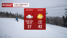
Snow continued Saturday afternoon for Northern New England, as a mix of sleet and rain fell in and around the Boston area. High temperatures hovered around the middle 30s.
A brief period of snow on the backside of the system is possible by mid-afternoon, but any snowfall we do see will not add to accumulations.
Tonight, the skies slowly clear, and temperatures drop below freezing. Watch for icy spots on untreated roadways that were previously wet.
Sunday is partly cloudy and pleasant, with highs in the lower 40’s.
Get Boston local news, weather forecasts, lifestyle and entertainment stories to your inbox. Sign up for NBC Boston’s newsletters.
For Monday, we’ll have breezy conditions with increasing clouds. Light snow is possible, by later in the evening. Highs around 40.
Tuesday morning could feature some light snow, then skies will be mostly cloudy. Highs around 40.
Quiet weather for Wednesday, Thursday, and Friday upcoming. Highs in the lower 40’s each day, with partly cloudy to mostly sunny skies.
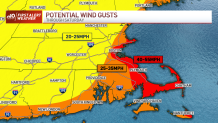
Winds have increased through the night, with gusts approaching (and surpassing) 40 mph along the coast. Combined with a small accumulation of wet, heavy snow, there might be some power outages. Elsewhere, the winds won’t be as strong, but where the snow does pile up to near 6 inches, there might be some isolated outages just from the sheer weight of the snow.
As the storm continues to pull away, the snow will taper slowly from west/northwest to southeast later this afternoon and evening. Storms of this nature are reluctant to give up, and this one will pester us with flakes until evening…even though the storm center is far from New England.
Sunday sees the Sun return along with some melting. Highs reach to the low 40s. The pattern is less active next week, but we’re watching another storm late into next week/weekend.
Be safe and enjoy your weekend!