
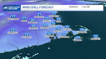
Buckle up, these temperatures keep dropping. Our wind is grabbing speed and will gust over 25 mph to 30 mph at times. This will bring our wind chills down to the 30s Sunday evening and into the 20s and teens Monday morning.
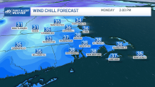
The good news is we’ll have the sun over us Monday fighting off the cold temperatures. The wind will be gusty early in the morning but will subside in the evening hours. Highs Monday will show mid 40s but will feel in the upper 30s at the warmest time of the day.
Tuesday brings more clouds with another cooler than average afternoon, highs will remain in the mid to upper 40s.
Get Boston local news, weather forecasts, lifestyle and entertainment stories to your inbox. Sign up for NBC Boston’s newsletters.
Sign up for our Breaking newsletter to get the most urgent news stories in your inbox.
Wednesday is the jackpot, snow is in the forecast and a wintry mix may reach as far east as Worcester County early in the morning. The snow there, however, will likely switch back to rain as warmer temperatures incorporate. The snow will push from the Berkshires into the green and white mountains early. The snow out in the Berkshires may end up as rain with a moist and southwest flow. But the snow in the mountains will extend all the way up northeast into the crown of Maine. Early forecasts indicate up to 6 inches of snow possible in and around Mt. Washington.
The wind will also be another factor in the day on Wednesday as the pressure gradient increases. Thursday may bring a few left over showers but will work into drying out and clearing up the skies by Thursday night into Friday.
More on the storm hitting Mass., NH and New England Friday and Saturday


The 10-day forecast lets us prepare for a cold week ahead, temperatures will remain in the 40s through the following weekend and out into the week of the 18th. Bundle up.
