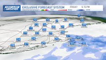
As Friday started, temperatures were a touch "milder" by a few degrees and the wind was calm.
Highs Friday will remain below freezing for all as we see snow develop.
How much snow are we getting?
Get Boston local news, weather forecasts, lifestyle and entertainment stories to your inbox. Sign up for NBC Boston’s newsletters.
A low pressure system passes well to our south, but some of the snow showers brush across southern New England. western Connecticut will see a coating — 2 inches of snow Friday afternoon. But around Rhode Island, we see a coating to 1 inch. With most of Massachusetts getting scattered coatings, nothing north of the Pike.
Southeastern Massachusetts will see the most snow from this system. As our winds turn from the northeast, we have ocean effect bands that develop Friday afternoon and evening.
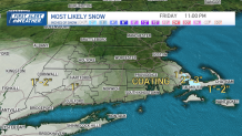
The colder air over warmer water offshore gives us this phenomenon where local towns in Plymouth County, Bristol County or the upper Cape will see 2 to 3 inches.
Cold returns Friday night as temperatures fall to the single digits and teens.
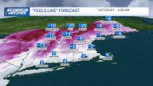
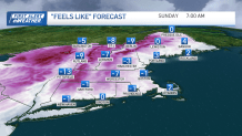
With some gusty northwest winds our wind chills fall to below zero Saturday and Sunday mornings. Saturday afternoon highs remain in the teens, with Sunday's highs in the 20s.
We begin next week with dry weather and modifying temperatures to the mid 30s through midweek. The forecast temperatures have trended lower each model run as a Canadian high pressure system suppressing the warmth from the south.
We will still see some 40s, but as a couple systems roll through starting on Tuesday, we still have a wintry mix in the forecast then and again at the end of next week.