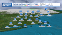
Clear skies through Tuesday bring another warm day regionwide.
While not as hot as Monday, we're still under early summer warmth with highs in the upper 60s (near 66° in Boston). There will be a partly cloudy sky with mild air Tuesday night and the overnight hours remain dry.
Wednesday turns cooler, as our winds shift from the east, there's a marked difference in temperatures for Boston and central Massachusetts. Areas near Worcester and Natick will be in the 60s, while Boston stays in the mid-50s.
Get Boston local news, weather forecasts, lifestyle and entertainment stories to your inbox. Sign up for NBC Boston’s newsletters.
The real shift happens Thursday with a weather system that drops south. It seems like the worst of the weather won't be our problem, but scattered showers throughout Thursday can't be ruled out. Because of clouds, Thursday will be cooler than normal with highs near 53° but we're back in the upper 50s on Friday and Saturday.
Saturday is the second chance for rain but won't last all day. The rain seems to be a morning to midday issue, with late day clearing expected.
It seems like we'll still go several days without steady and heavy rainfall, so the fire danger will need to be watched as dry conditions settle in, with warmer temperatures.