
Cooler temperatures welcome us into this week and spring begins on Tuesday.
For Monday, it will feel pretty wintry in the mountains with snow showers, a gusty wind and high temperatures in the 30s on the summits, with 40s to around 50 elsewhere. A mix of clouds and sun will be expected Monday on our last full day of astronomical winter.
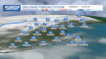
As spring begins Tuesday, our temperatures cool a bit into the mid-40s for highs. At night, our lows drop to the 20s in the suburbs to 30s. This is actually where we should be this time of the year, with Boston averaging a high of 46, low of 32.
Get Boston local news, weather forecasts, lifestyle and entertainment stories to your inbox. Sign up for NBC Boston’s newsletters.
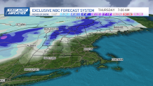
A clipper system passes to our north Wednesday into Thursday morning, and this will swing in some snow showers north and in higher elevations, to rain showers south.
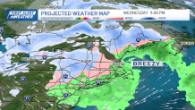
Highs reach the 40s for Wednesday, with cooler temps in the low 40s on Thursday after a cold front passage.
Snow accumulation will be confined to high terrain and mainly in the mountains where several inches can be expected late Wednesday. Some snowflakes may mix around Boston briefly Wednesday overnight as the system passes through. Cooler temps remain for not only Thursday, but Friday, too.
The weekend brings us another chance for precipitation on Saturday. Rain south and snow in the mountains as a low-pressure system passes across southern New England.
Local
In-depth news coverage of the Greater Boston Area.


The timing and precipitation type is still to be determined this far out. Sunday through Monday of next week we seem to dry out with highs still in the low 40s.
