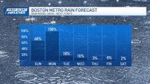
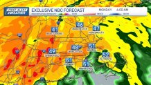
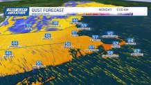
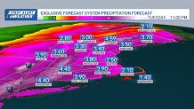
Another Monday, another powerhouse storm system moving through New England. This is shaping up to be an impactful storm system with the potential 55 to 65 mph wind gusts and another round of very heavy rain. Rain will become more widespread and increase in intensity tonight.
At the same time, the deepening low pressure system will generate strong winds that will easily mix down close to ground level. That will translate into wind gusts in excess of 60 mph on the Cape and up to 55 mph in the Boston metro area stretching back to central Massachusetts.

This could very well lead to power outages and potential for tree damage … especially since we just had a round of recent rain and the soil may be softer than usual. Secure or take down any holiday décor that could go airborne in these strong winds.
Get Boston local news, weather forecasts, lifestyle and entertainment stories to your inbox. Sign up for NBC Boston’s newsletters.
The Monday morning commute will be a mess for the metro area. Very heavy rain and some of the strongest winds we will experience are forecast to occur around 5 AM to 9 AM.

Allow for a lot of extra time for any driving you have to do on Monday. If you’re flying, check with the airlines as delays are likely. Rain will continue through the mid morning hours before we get a break sometime around noon. Another batch of rain (and perhaps a few thunderstorms) may take place during the late afternoon/early evening hours.
Once that batch moves out, we should see a general decrease in the overall rain coverage. We start drying out Monday night … and Mother Nature will provide a strong wind to speed up the drying-out process.

While a few more showers may occur on Tuesday, the overall pattern favors drier and quieter weather for the rest of the week all the way through Christmas Day. For Christmas Eve and Christmas Day (Sunday and Monday), highs should be in the mid to upper 40s. No white Christmas in the forecast for a large part of New England this year.


