Tuesday night: Any showers dwindle, coastal fog. Lows around 40. Wednesday: Fair sky, a few late day and evening showers. Highs in the 50s. Thursday: Few showers, partly cloudy. Highs in the 50s.
Our repetitive weather pattern continues in New England, though it’s not a terrible pattern to be stuck in — robust breaks of sun during the morning that burn through early clouds and fog, then building afternoon clouds with scattered showers, meaning both the sunglasses and umbrella get some use each day.
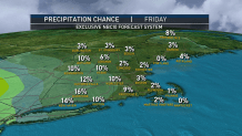
As these April showers continue for days on end, the added value our First Alert Team tries to provide is with more specific detail on where and when raindrops will fall. We employ several different tools to provide unparalleled detail for our viewers, including day-by-day chance of precipitation maps generated by our exclusive NBC Forecast System, as well as using our exclusive system to illustrate timing and intensity of showers.
WATCH ANYTIME FOR FREE
Stream NBC10 Boston news for free, 24/7, wherever you are. |

Tuesday’s pockets of thick fog thinned as the sun rose and showers aren’t expected to develop until at least 2 p.m. for most of central and southern New England, though raindrops continue falling in parts of Maine under a stalled band of showers. Elsewhere, the afternoon showers will mostly avoid the South Coast and Cape Cod, and won’t drop heavy rain amounts anywhere but will continue at least in scattered form past dinnertime, slowly fizzling after sunset.
Get updates on what's happening in Boston to your inbox. Sign up for our News Headlines newsletter.
With a sea breeze developing, high temperatures around 60 degrees inland will be about 5 to 10 degrees cooler at the shore, then fog banks will drift toward the coast from the ocean during the evening and night, while additional areas of fog develop inland where any showers fall. Yet again, fog and clouds will break up Wednesday, but this time, showers aren’t expected until late afternoon – around 4 p.m. onward – and mostly will be found away from the coastline, for inland communities. A rumble of thunder is possible with Wednesday evening’s showers as the center of upper atmospheric energy that’s been sparking our daily showers finally approaches, keeping scattered showers alive into Wednesday night and at least in scattered for Thursday, until the disturbance tracks east and allows showers to dwindle later Thursday afternoon to evening.

The dry respite should last through Friday and at least Saturday midday, but by later Saturday, rain will approach from the southwest. Like this week’s disturbance, the one developing along the East Coast this weekend looks to slow enough to keep at least scattered showers in the forecast through the first half of next week in our exclusive First Alert 10-day forecast. That said, much of New England is still running below normal for rainfall in the month of April! As for temperatures, we continue to see no exceptional warmth or cold in the 10-day forecast, with near-normal or slightly below normal temperatures through the 10-day period.

