
The weekly Drought Monitor update rolled in Thursday morning and recent thunderstorms simply haven’t been enough to stop the slide for eastern Massachusetts and southern Rhode Island, now upgraded from Severe Drought to Extreme Drought from the government/university consortium that issues the national assessment.
We did see some improvement in northern New England, with much of the Upper Valley and Mountains actually sliding out of drought thanks to recent thunderstorms with torrential downpours. Although very limited rain will fall in parts of New England Thursday, it won’t be impactful on the drought – amounts will be quite light, on the order of a tenth of an inch or less, even in the spots that see steadiest rain.
Lots of clouds during the day drop rain showers from the Boston Metro to southeast Connecticut points southeast, wrapping up from west to east, early afternoon to early evening, northwest to southeast. Further northwest, scattered showers in northern New England Thursday won’t creep into central New England, or central to western Massachusetts and Connecticut, where the day should stay dry.
Get Boston local news, weather forecasts, lifestyle and entertainment stories to your inbox. Sign up for NBC Boston’s newsletters.
Thursday night brings the full Sturgeon Moon to New England, rising just after 8 p.m., officially reaching full just after 9:30 p.m. and the final “Supermoon” of the year, just a bit closer and a bit brighter than a typical full moon, and exerting just enough gravitational pull on Earth to deliver high enough tidal levels for some splash over and very minor coastal flooding in typically vulnerable spots at the near-midnight high tides Thursday and Friday nights.
Thinning Thursday evening clouds not only will make way for a view of the Supermoon, but also for glimpses of the Perseid Meteor Shower, set to peak Friday night but already visible with occasional meteors in our night sky.
Weather Stories


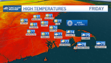
As the night wears on, partly cloudy skies will eventually combine with pockets of dense fog in eastern New England that will linger into Friday morning before thinning out. Friday will feature more clouds than sun as a large area of upper level energy slowly gathers over the Northeast U.S., prompting scattered afternoon rain showers, particularly in eastern New England, as high temperatures reach to around 80 degrees with a moderate amount of humidity.
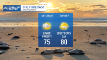
New Englanders may want to get used to the feeling of the temperatures and humidity these next few days, seasonable for this time of the year but also where we’ll land for just about the entire First Alert 10-day forecast. The chance of showers fluctuates as various upper atmospheric disturbances ripple through the jet stream winds aloft, parked over the Northeast next week and therefore raising the chance of showers on several days in the 10-day forecast, but particularly centered around midweek next week.

