
Our First Alert continues Friday night for the dangerously cold temps, wind chills and even a short period of time where we get a flash freeze concern southeast.
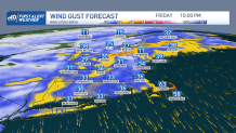
Temperatures have been in the 40s all day across southern New England. Southeastern Massachusetts has had rain all day too, so any standing water that doesn’t evaporate quick enough before temperatures come crashing down this evening will freeze. Temperatures fall to the teens and 20s by 11 p.m. in areas like Boston and Cape Cod as the ocean storm pulls away and as our wind increases from the north.
Saturday: Cold and Windy
Get Boston local news, weather forecasts, lifestyle and entertainment stories to your inbox. Sign up for NBC Boston’s newsletters.
Damaging winds are possible between 9 p.m. and 5 a.m. Saturday along the south shore, Cape and islands. Watch for trees down or outages. This north wind ushers in bitter cold for Saturday.
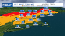
Lows drop to below freezing in northern New England, around zero in southern New England. But oh, the wind chills! They will be brutal, in the -15 to -35 degree range for the "feels like" Saturday morning. Frostbite could set in in 30 minutes or less, so it’s another day to make sure you don’t have exposed skin as you head out. When it’s this cold again, drip those faucets, and bring in your outdoor pets. Saturday afternoon’s highs will be 0-10 and still with a wind chill below zero. The gusty wind sticks around in the mountains and there may be ski lift delays.
Local
In-depth news coverage of the Greater Boston Area.


Sunday: Sunshine and Less Wind
Sunday we have a break from the intense weather with 20s and sunshine plus less wind. Sunday night into Monday our next storm heads in.
Monday: A Messy Winter Storm
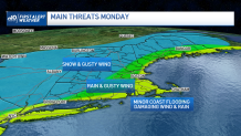
This one is likely to track along or just inside the coastline of the east, the center of the low-pressure system heads into western New England. This storm will be messy, with temps in the 40s southeast and rain. Colder temps and snow will be likely for northern and western New England. Several inches of snow will fall to around one foot in northwestern New England, and some upslope snow may enhance our totals in the mountains too.
The snow is all day long Monday, which is a popular ski weekend since it’s Martin Luther King Day Monday. Stay tuned as the track may wobble slightly and then we could increase our totals for Boston a bit. It is looking more likely that the highest threats for Boston will be gusty winds and rain, not a lot of snow. Wind speeds increase as the storm moves through Monday, southeast gusts around 40-60+ mph then southwests gusts in southern New England.
Northern New England will see more northeast to northwest winds. At the coast, the waves will be churning around high tide (noon and midnight Monday). Southern and eastern facing beaches have a chance for minor to moderate coastal flooding with up to a 3-foot surge around the noon high tide Monday. The thing is that our tides are running astronomically lower (about 9.5’ for Boston on Monday afternoon). But with wave heights offshore 15-25 feet we will see some impacts there.
Our weather pattern quiets down after Monday, with temps in the 30s to 20s and a small system bringing in snow showers sometime midweek.
