Tornado warnings have expired after being issued Thursday afternoon in parts of Massachusetts, New Hampshire and Vermont, but the threats of severe thunderstorms continued hours later in much of New England.
Severe thunderstorm warnings were in effect in parts Maine, New Hampshire, Vermont, Massachusetts and Connecticut for parts of the afternoon and evening, but they have since expired.
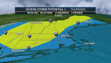
The potential for more severe weather continues as thunderstorms move through New England on Thursday afternoon. A severe thunderstorm watch was in effect for the region for much of the evening, with wind gusts expected to reach 75 mph.
See severe weather alerts in your area here.
Get Boston local news, weather forecasts, lifestyle and entertainment stories to your inbox. Sign up for NBC Boston’s newsletters.
The storms led to the death of a 9-year-old girl in Maine after a tree fell on the car, authorities in that state said.
Thursday's tornado warnings came after tornadoes touched down in New Hampshire and Vermont on Monday night.
The severe thunderstorm threat during the afternoon and evening will stretch from the northwest to southeast across New England, though areas south and east of a line from Boston to Providence will probably wait until evening before any storms arise.
New England's heat wave continues. It isn’t a new story, but it does reach a new impact on the body Thursday, into dangerous levels for some. That makes hydration, breaks in outdoor activity and respites in air conditioned places all the more important.
Heat and humidity are reaching one peak Thursday, with another expected Sunday. Each of the days sport temperatures into the 90s with dew point temperatures reaching oppressive values in the 70s, boosting heat index values to around 100 degrees.
Heat index is often referred to as "feels like temperature," measuring impact on the body, and represents the body’s decreased ability to cool in hot and humid conditions. Our bodies are able to cool by sweating, but more specifically, when sweat evaporates, the body cools. With abundant humidity, sweat doesn’t readily evaporate off the body and therefore isn’t as effective at cooling, meaning, under normal humidity conditions, the temperature “might as well be” the heat index value.
For tips on how to stay safe and cool, click here.
From an atmospheric perspective, the abundant heat and humidity provide ample fuel for thunderstorms to erupt as an energetic disturbance aloft couples with a surface cold front to focus storm development from northwest to southeast during the afternoon and evening.
Get updates on what's happening in Boston to your inbox. Sign up for our News Headlines newsletter.
Incoming dry air aloft will couple with increasing elevated wind to promote swaths of damaging wind gusts in Thursday thunderstorms, prompting severe thunderstorm warnings. Be ready to seek shelter if storms threaten your community. Keep in mind lightning doesn’t prompt a severe thunderstorm warning like wind and hail do, so remembering "when thunder roars, go indoors," helps to keep folks safe from regular, non-severe thunderstorms.
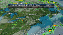
Scattered storms will slowly wane overnight Thursday and less humid air arrives for Friday and Saturday but the heat continues. Although storms won’t be commonplace Friday and Saturday, isolated storms certainly are possible just about anywhere in New England in the intense heat.
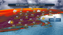
An increasing south wind Sunday will bring a return of oppressive humidity, heat index values around or over 100 degrees and perhaps some scattered afternoon or evening thunder. More widespread showers and thunder are expected Monday as a cold front “breaks” the heat. We use that term cautiously as temperatures will still reach 85 to 90 degrees for daily highs most of next week in the exclusive First Alert 10-day forecast!