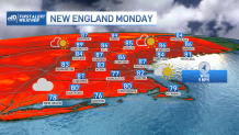
Monday’s weather has varied somewhat dramatically from one spot to another in New England, with large pockets of stubborn clouds offsetting large areas of sunshine.
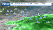
The result is somewhat uneven heating – some jumping into the 80s while others hold in the 70s. By the day's end, though, most of us will likely have spent time under both clouds and sun, and most of us will end with high temperatures in the 80s. Look for moderate humidity amid scattered showers that redevelop during the afternoon, waning gradually after dark to leave lots of clouds with patchy fog.
Monday’s variable weather comes just ahead of a new push of hot and humid air, set to take hold Tuesday with high temperatures bumping to around or over 90 degrees for many. A cold front approaching Tuesday afternoon will cause scattered thunderstorms to develop from early afternoon into the evening. Most storms will produce briefly heavy rain, but some storms are capable of growing strong, fueled by the heat and humidity, cranking up some locally damaging wind gusts during the later day and early evening.
Get Boston local news, weather forecasts, lifestyle and entertainment stories to your inbox. Sign up for NBC Boston’s newsletters.
The air that arrives behind the cold front will be only marginally cooler, with inland communities still reaching 85 to 90 degrees Wednesday. Humidity will still hang on in far southern New England and an isolated storm is possible, though not likely, in southern New England on the northern edge of that humidity.
Closer to the coast, sea breezes will develop Wednesday, holding high temperatures to between 80 and 85 degrees. New England makes up for lost time regarding the heat by Thursday, when a surge of southwesterly wind ushers in some exceptionally hot air, likely to boost temperatures into the middle and upper 90s.
Our First Alert forecast for Boston is 98 or 99 degrees, which would break the old record for the date of Aug. 4, which is 96 degrees from 1928.
Again, a cold front is expected to arrive by Friday, creating scattered thunderstorms and starting a slow decline in heat and humidity heading into Saturday, though 90° is reachable once more Sunday before a step to somewhat cooler, but still summery, air next week in our 10-day forecast.
While we’re looking further out, we released our August monthly forecast Monday and it looks like warmer-than-normal weather rolls on for the month, overall, with near normal rainfall possible in southern New England and drier-than-normal conditions in the north. Either way, no clear signals we’ll make any big improvement on the drought this month if the forecast holds.