
-

Super weather leading into Memorial Day weekend + 2024's hurricane forecast
Thursday evening: First Alert Day. Scattered rain & Storms. Temps in the 70s. Overnight: Drying out. Humid. Low: 64. Friday: Warm Day. Sunny. High: 83. Saturday: Sun & Clouds. High: 78.
-

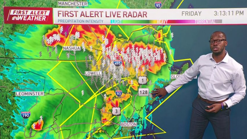
FIRST ALERT: Strong thunderstorms possible
Today (Thursday): First Alert Day. Midday Showers & Storms. High: 81.
Overnight Tonight: Drying out. Humid. Low: 64.
Friday: Warm Day. Sunny. High: 83.
Saturday: Sun & Clouds. High: 78.Follow NBC10 Boston on…
Instagram: instagram.com/nbc10boston
TikTok: tiktok.com/@nbc10boston
Facebook: facebook.com/NBC10Boston
X: twitter.com/NBC10Boston -

Severe thunderstorms bring heavy rain, lightning, damaging winds, hail
We had a First Alert day Thursday for scattered thunderstorms forecast for the afternoon through sunset. We already had a few showers and thundershowers Thursday morning. Severe thunderstorm warnings were issued for parts of Connecticut, Rhode Island and Maine, along with flash flood warnings in the Providence, Rhode Island, and New Bedford, Massachusetts, areas. Click here for the latest weather…
-

Forecast: Showers and storms Thursday
Today (Thursday): First Alert Day. Midday Showers & Storms. High: 81.
Overnight Tonight: Drying out. Humid. Low: 64.
Friday: Warm Day. Sunny. High: 83.
Saturday: Sun & Clouds. High: 78.Follow NBC10 Boston on…
Instagram: instagram.com/nbc10boston
TikTok: tiktok.com/@nbc10boston
Facebook: facebook.com/NBC10Boston
X: twitter.com/NBC10Boston -

Weather forecast: Scattered morning rain
Wednesday night: Cloudy. Low: 50. Thursday: Scattered rain mid-morning. Cooler. High: 57. Friday: Cloudy and cool. Rain. East wind of 10mph. High: 52 degrees.
-

Track the intense storms move into Boston area
Wednesday evening: Thunderstorms & showers taper, mostly cloudy. Temps in the upper 50s. Overnight: Cloudy. Low: 50. Thursday: Scattered rain mid-morning. Cooler. High: 57. Friday: Cloudy and cool. Rain. Wind: E10mph. High: 52 degrees.
-
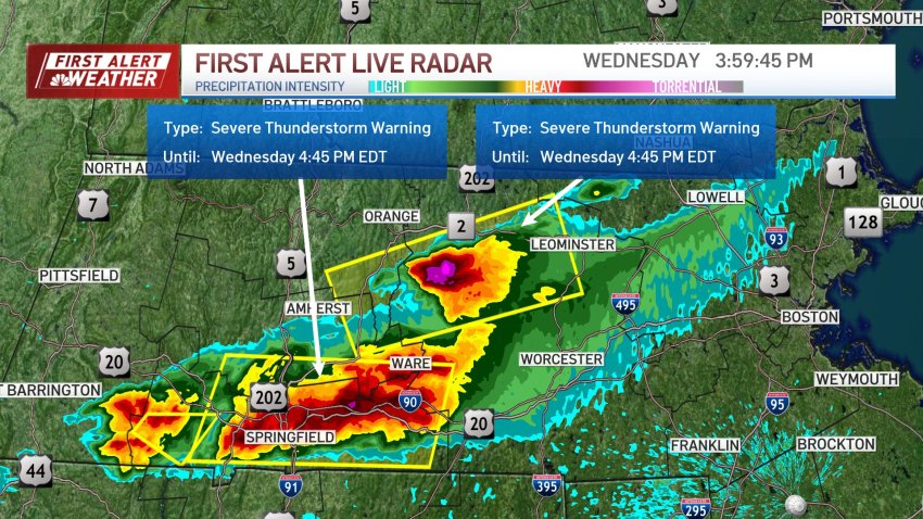
Severe storms cross New England
Track storms moving through Massachusetts on Wednesday with live weather radar, and get the Boston area’s latest forecast.
-

Second round of rain on the way, isolated thunderstorms possible
Wednesday: First Alert: Morning Showers. Afternoon Thunderstorms. High: 62.
Overnight Wednesday night: Cloudy. Low: 50.
Thursday: Scattered rain mid-morning. Cooler. High: 57.
Friday: Cloudy and cool. Rain. Wind: E10mph. High: 52 degrees. -
Flash flood warning for parts of Mass., Rhode Island
Showers have already started in southern New England, with localized heavy downpours south of the Mass Pike. The rain is expected to increase in coverage this afternoon, with the possibility of thunderstorms, although the main concern is heavy downpours & lightning. A flash flooding is in effect for parts of Massachusetts and Rhode Island, and the Sagamore Bridge to Cape…
-
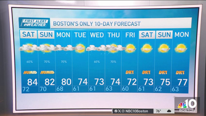
Stormy weather continues in New England
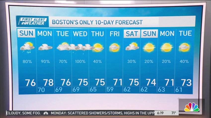
Today: Humid, showers/storms, highs in the upper 70s. Overnight: Lows in the upper 60s, cloudy, some fog. Monday: Scattered showers/storms, highs in the upper 70s, humid, mostly cloudy.
-
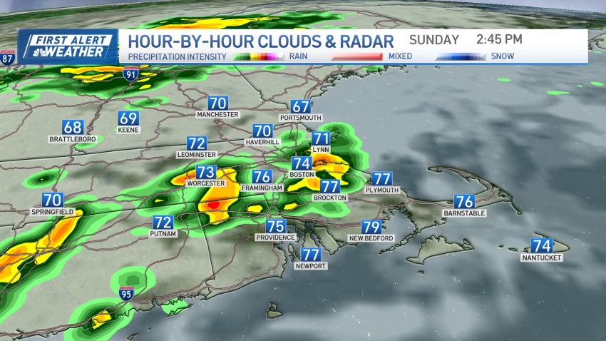
Humid, stormy weather continues on Sunday
Our stormy, and humid weather continues through the entire weekend on this Sunday. A stationary front is right across New England and will provide another day of showers, storms and maybe a strong storm with gusty wind, heavy rain and lightning. The showers will be around this morning, with another round in the afternoon to evening. More clouds are expected…
-
Humid and stormy weather continues on Sunday
Today: Humid, showers/storms, highs in the upper 70s. Overnight: Lows in the upper 60s, cloudy, some fog. Monday: Scattered showers/storms, highs in the upper 70s, humid, mostly cloudy.
-
A humid Sunday, with scattered showers and storms
Overnight: Cloudy, muggy, patchy fog, passing shower. Lows near 70 east, upper 60s inland. Sunday: Humid, scattered showers and storms. Highs around 80. Monday: Still humid. A couple pm showers. Highs in the 70s.
-
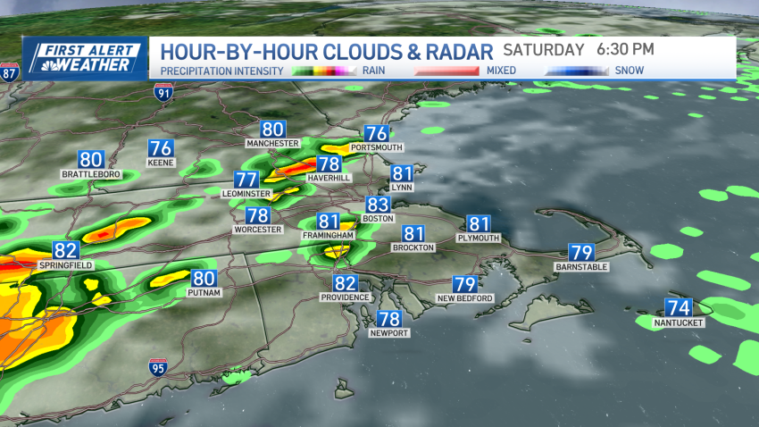
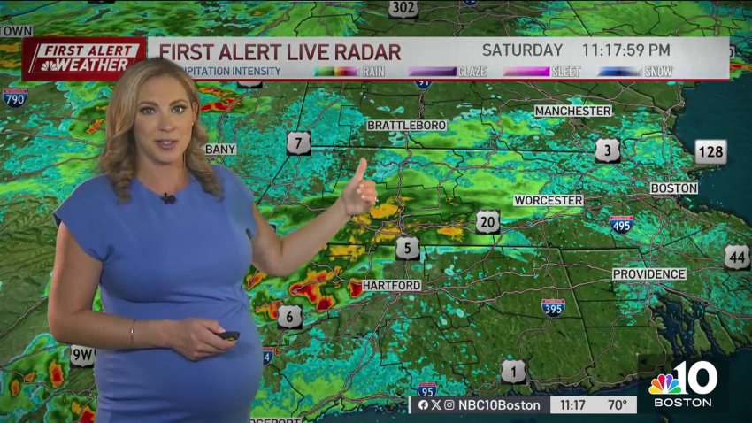
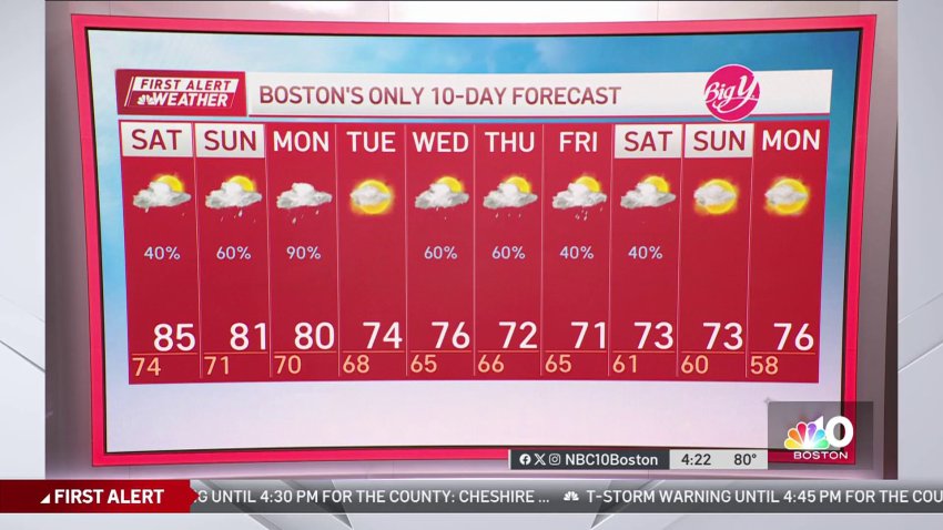
More showers and storms Saturday in New England
New England continues under cloudy skies, humidity, warmth as well as showers & storms this afternoon. The severe weather threat is lower compared to yesterday. Some showers and storms are forming in south central Connecticut, and moving into the northeast by the evening. Reaching inside I-495 in the middle of the day. Click here for the latest weather alerts. Highs…
-
High humidity with possible storms on Saturday in New England
After yesterday’s severe weather event, we’re all on pins and needles with the idea of more storms in the forecast. Today’s setup isn’t as robust as yesterday, but it’s possible that isolated severe storms pop up this afternoon. Humidity will remain high, so heavy rain will also be part of the equation (again). Placement and density is another consideration...
-
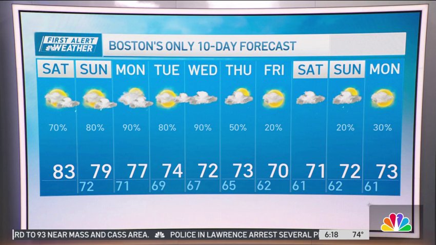
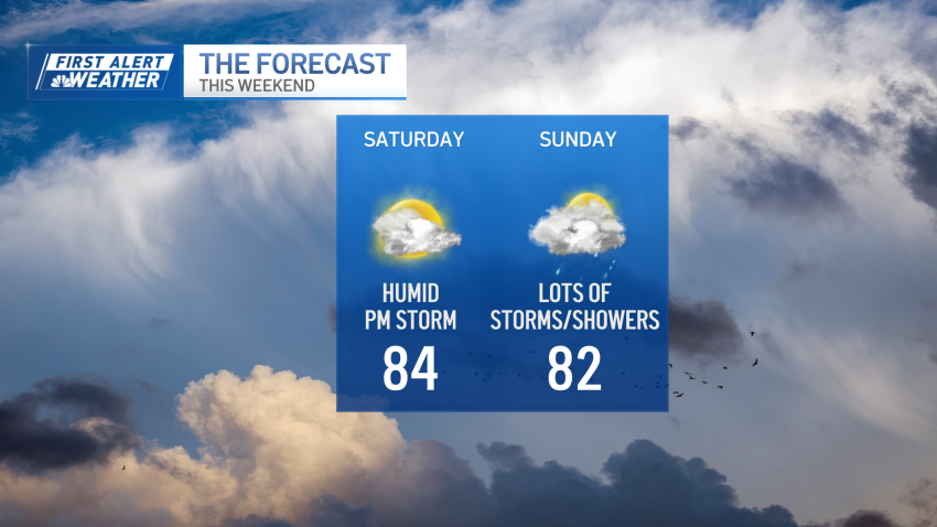
Humidity remains high after Friday storms
Today: Humid, mix of sun & clouds, highs in the 80s, late pm/evening showers & storms. Overnight: Lows near 70 east, upper 60s inland, cloudy, humid. Sunday: Humid, showers/storms, highs around 80.
-
Weather forecast: More weekend humidity and showers
Friday night: Humid, few leftover showers taper off, lows in the 70s. Saturday: Humid, mix of sun and clouds, highs in the 80s, late afternoon/evening showers and storms. Sunday: Humid, showers/storms, highs around 80.
-
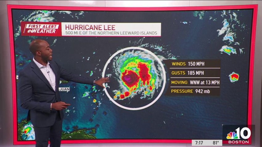
Weather forecast: Tracking Hurricane Lee as New England storms taper off
Friday night: Humid, few leftover showers taper off, lows in the 70s. Saturday: Humid, mix of sun and clouds, highs in the 80s, late afternoon/evening showers and storms. Sunday: Humid, showers/storms, highs around 80.
-
Leftover showers taper off overnight
Overnight: Humid, few leftover showers taper off, lows in the 70s. Saturday: Humid, mix of sun & clouds, highs in the 80s, late pm/evening showers & storms. Sunday: Humid, showers/storms, highs around 80.
-
Forecast: Quick look at storms moving into Boston area
Overnight: Humid, few leftover showers taper off, lows in the 70s. Saturday: Humid, mix of sun & clouds, highs in the 80s, late pm/evening showers & storms. Sunday: Humid, showers/storms, highs around 80.
Trending
