Our front (and rain) finally moved offshore very early this morning. Not after dropping a tornado in Connecticut and spinning up a waterspout (a tornado over water) off of Wellfleet.
Now that that’s out of the way, the sun returns today. As a pool of cool air spins overhead, clouds will build into our blue skies and a couple of weak, fast-moving showers may pop up this afternoon. Nothing to cancel plans over, but just don’t be dumbfounded if you get tagged by one.
That cool air has staying power too. Lows will dip back into the 40s in some suburbs tonight under a starry sky.
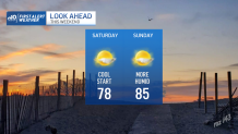
Sun will dominate the weekend, and we’ll see a slow warming trend. Highs recover Saturday to the mid and upper 70s. Sunday sees a return to the low and mid-80s. Not too shabby for the first day with the sunset inside 7 p.m. (And a little over a week to the equinox.)
Get Boston local news, weather forecasts, lifestyle and entertainment stories to your inbox. Sign up for NBC Boston’s newsletters.
If you’re heading to the beach to dip your toes in the water, keep in mind that Hurricane Larry has stirred up the waves offshore. Those wave sets began arriving yesterday and will continue to approach the coast from the southeast into the weekend.
With winds switching to the northwest today, the setup is ideal for some sweet surfing. Apparently (from what surfer friends have told me), the northwest winds help “stand-up” the waves as they approach the beach, making them more uniform and helping to shape them into rideable waves.
Weather Stories

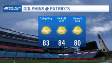
For the non-surfer and landlubbers, the forecast looks stellar for any outdoor plans this weekend. The Patriots game is also a toasty one for both tailgating and the actual game. Shorts and Jones jerseys (if you can find them…second best in the NFL right now) all around.
Have fun and be safe this weekend.