
Many of you have Monday off in observance of July 4th, and while our Monday weather is probably still nowhere near the weather many of us had been dreaming of for the Independence Day holiday, it’s an improvement over the weekend.
New England’s weather has delivered a bit of whiplash in the last week – from a record 100° reading in Boston last Wednesday, to a record cold high temperature of 61° in Boston this past Saturday. And now we’ll see the city and much of New England, at large, climbing back into the 90 degree range by Tuesday with a heat index expected to exceed 95°, prompting a First Alert from our weather team.
Of course, amidst all these changes in air one might expect unsettled weather, and nature hasn’t disappointed in this regard, either, with nearly half a foot of rain in the past week for many communities, and some even recording more than half a foot!
Although this has helped to put a dent in the drought that existed on Cape Cod and Northern New England, it’s also left gardens waterlogged and it looks like many gardeners won’t need to water in the days ahead.
Get Boston local news, weather forecasts, lifestyle and entertainment stories to your inbox. Sign up for NBC Boston’s newsletters.
After Monday sprinkles from bubbling clouds, a parade of disturbances aloft will continue to cross our New England sky as air near ground level turns warmer and more humid – tangible in southern New England Monday night and for all of New England Wednesday, and priming the atmosphere for a chance of showers predawn Tuesday, then stronger thunderstorms with a follow-up disturbance Tuesday late day and evening.
In fact, with the heat and humidity we’re expecting Tuesday, chances are good we’ll see some strong thunderstorms late Tuesday that may produce frequent lightning and damaging wind gusts.
By Wednesday, a cold front slowly crosses New England from the north, cooling northern New England somewhat but likely slow enough for southern New England to reach around 90 degrees again with humidity and a chance of afternoon thunder.
New air arrives Thursday with much cooler temperatures, but the cold front that delivered the new air won’t be far and a storm center will come rippling along it, raising the chance of rain and thunder later Thursday into Friday.
Elsa Coverage

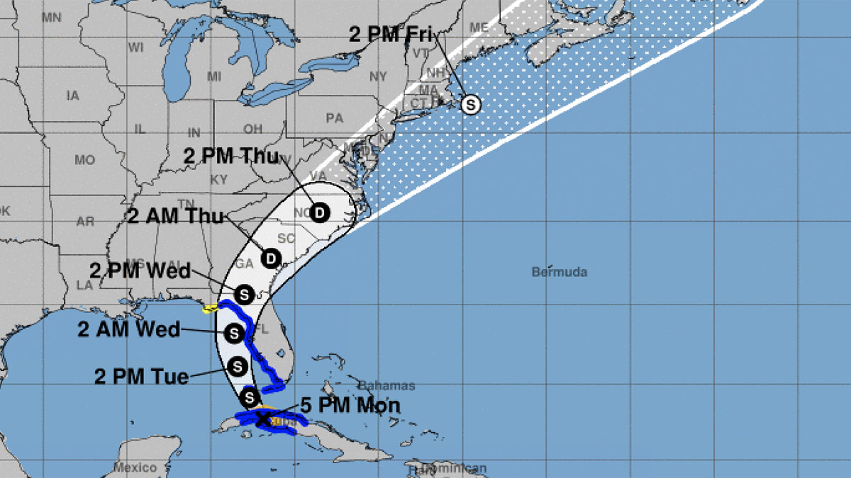
Potentially adding more moisture to the mix will be Tropical Storm Elsa, currently over Cuba and forecast to track north, parallel to or scraping along the west coast of Florida Wednesday, crossing the southeast U.S. Thursday and making its closest pass southeast of New England on Friday. While the wind field will stay southeast of New England, some of Elsa’s moisture may enhance an already unsettled late week forecast.
Following Elsa’s passage, a pattern of warm and humid weather with late day thunder looks to set up for several days on end from this weekend into next week.
