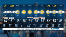
Unsettled weather will persist today across New England with cooler temperatures throughout the region. Expect scattered showers throughout the day with highs only reaching into the 60s.
Overnight, we will have cloudy skies with drizzle, showers and fog as an area of low pressure passes south of the region. Lows will be in the 50s. More of the same is on tap for Saturday as yet another round of rain moves in. Expect periods of rain throughout the day under cloudy skies, with highs again only reaching into the 60s.
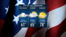
Independence Day features early showers with overcast skies turning to breaks of sun by the second half of the day. Highs will reach into the upper 60s to low 70s. It won’t be an ideal beach day given a persistent onshore wind.
Those who do venture to the beach and get into the water will need to watch out for rough surf and dangerous rip currents. For those at a backyard BBQ, you may have to duck inside for a time during the afternoon for any passing showers. For fireworks, not expecting a big impact from the weather.
Get Boston local news, weather forecasts, lifestyle and entertainment stories to your inbox. Sign up for NBC Boston’s newsletters.
A warm front approaches New England from the south on Monday, bringing an increased threat of showers. Expecting skies to be mostly sunny with highs rising into the mid to upper 70s.
Hot and humid weather returns on Tuesday with heat indices possibly reaching into the low to mid 90s. Highs reach into the upper 80s to low 90s
A cold front will bring showers and thunderstorms to the region on Wednesday. We’ll have to keep an eye on the potential for stronger storms. Highs on Wednesday reach into the mid to upper 80s on the exclusive First Alert Weather 10-Day Forecast on NBC10 Boston and NECN.