It's a cool evening in New England Friday, one in which you might find yourself bundled up already with sweaters or a coat. Our temperatures will drop into the 40s again Friday night, but this time accompanied by rain.
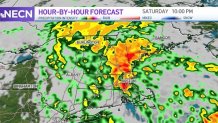
After midnight, showers will begin to make their way into the southwestern side of New England, and as we wake up, we'll find scattered showers making it to the northern sections.
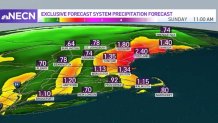
But the heaviest precipitation will likely filter in after 5 p.m. Mostly affecting eastern New England, these showers will continue through 10-11 p.m. over eastern Massachusetts, southeastern New Hampshire and southwestern Maine.
Adding up our rainfall totals, the most affected spots might be gaining up to 2 inches or just above that.
Get Boston local news, weather forecasts, lifestyle and entertainment stories to your inbox. Sign up for NBC Boston’s newsletters.
While we're not expecting a widespread risk of flooding, some streets -- ones with poor drainage or extra debris -- will have a difficult time draining that water by Saturday night.
With existing storm damage and stressed trees and outages still in southeast Massachusetts, additional isolated damage and outages could occur Saturday. Plus, those still without power will not get it back until Sunday, with gusts 35-45 mph headed for the coast. However this storm, unlike the last one, is not classified as a nor’easter.
Other than that, the forecast keeps improving for Sunday -- Halloween is giving us a treat! The skies will clear for the afternoon and evening hours.
Weather Stories


Our forecast has been looking better for the central and southern states of New England, but Vermont and Maine are vulnerable to some scattered showers. However, they're not expecting a complete washout, so it's not too bad.
Our temperatures for Sunday are looking good: we'll have highs in the 60s that should drop into the 50s for Monday and more on Tuesday. While we're starting November with seasonal temperatures and clear skies, we'll see a system making its way in Wednesday, but it won't be much of a problem.
By the end of the week, we'll see increasing rain chances, but next weekend is already looking good!
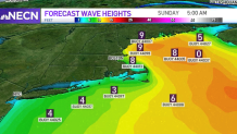
Our shores are having a difficult time calming down, since winds are keeping seas 5-9 feet high, and we'll watch these increase again, up to 10-13 feet, by Saturday night. It's likely for these to improve by Sunday afternoon into Monday morning.