A cool start this morning with temperatures starting out in the upper 30s to low 40s, but temperatures are expected to rebound nicely as we head through the morning into the afternoon.
High pressure will provide a dry and mild day but we will be dealing with some high, thin clouds as a system to our west starts to close in on the region.
High temperatures are expected reach the mid to upper 60s across western New England, upper 50s to low 60s towards the east, and 50s along the immediate coastline where an east-southeast wind off the cool ocean will keep things a bit cooler.
Get updates on what's happening in Boston to your inbox. Sign up for our News Headlines newsletter.
Get Boston local news, weather forecasts, lifestyle and entertainment stories to your inbox. Sign up for NBC Boston’s newsletters.
Winds may switch a bit more southerly later this afternoon, which could allow temps to bounce up a bit across some coastal communities, such as Boston.
Clouds will increase and thicken overnight with rain showers breaking out across northern Vermont into western southern New England late and shift eastward by daybreak. Lows tonight drop into the mid 40s south, upper 30s to around 40 north.
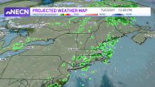
The threat for showers is in the forecast much of the day Tuesday as a cold front passes through the region with the focus north in the morning, south in the afternoon.
Late in the day, an area of low pressure will develop along the frontal south of New England, enhancing the threat for showers Tuesday night into Wednesday morning.
Low pressure will track north and will be stubborn to exit as it remains over Nova Scotia, keeping much of northern New England in a cool, damp pattern with occasional rain showers and mountain snow showers Thursday and Friday.
Southern New England is looking dry, breezy, and cool with the slight risk for showers Thursday and mostly dry conditions Friday as indicated on our Exclusive 10-Day Forecast.