High pressure builds into the region today and provides us with a couple of tranquil days as we kick off the new work week.
After some morning showers Monday, expect sunshine with a few clouds thrown in and a wind out of the northwest 10-15 mph. Temperatures will reach the low to mid 50s across southern New England, slightly cooler Cape and Islands, mid 40s to 50 north.
Tuesday is looking to be the pick of the work week with sunshine in the morning and some high, thin clouds increasing during the afternoon. Highs will reach the 50s across northern New England, cooler near the Canadian border, mid 50s to low 60s across the south.
Sign up for our Breaking newsletter to get the most urgent news stories in your inbox.
Get Boston local news, weather forecasts, lifestyle and entertainment stories to your inbox. Sign up for NBC Boston’s newsletters.
With a light west wind, it is likely we’ll see sea breezes developing along the coastline, which will drop temps a bit there during the afternoon, but that’s to be expected this time of year.
Showers will develop late Tuesday night as low pressure makes its way up the eastern seaboard. Expect a wet day Wednesday across southern New England into portions of southern New Hampshire and southern Vermont as the system passes to the south of the region.
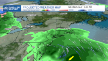
Northern New England gets spared of rain from this system, but won’t stay dry for too long as we focus our attention to another system, which looks to bring a widespread rain to the region. There may even be some wintry precipitation in far northern areas Thursday into early Friday.
The rest of Friday into the first portion of the weekend looks somewhat unsettled. An upper-level low will move through the region and kick off some showers from time to time, as seen on our exclusive First Alert 10-Day forecast. Still some wiggle room in that portion of the forecast, so stay tuned!