
We made it to the pick of the week for many, highs are in the 50s, we’re enjoying sunny skies and a breezy west wind that gusts from 20 to 30 miles per hour. Skies will remain mostly clear. The wind will slow down overnight before marching clouds make their way in before dawn Thursday.
On Thursday morning, we'll lookout for denser clouds as the midday welcomes snow showers and a wintry mix moving in from New York to the Berkshires and the green mountains. These snow showers will rapidly spread east into the white mountains and Maine by mid-afternoon.
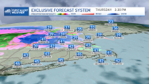
Massachusetts won’t see the same action nor precipitation type affecting the east and south. It’s likely that southern Massachusetts remains cloudy and mostly dry, although a few patchy showers may brush through from 4 to 10 p.m., adding a tenth of an inch in rainfall. The rain and mix of snow showers will push through Worcester in the early to mid-afternoon and briefly advance inside I-495 by midafternoon into the early evening. What comes down as snow in Massachusetts may turn into rain before midnight.
Get Boston local news, weather forecasts, lifestyle and entertainment stories to your inbox. Sign up for NBC Boston’s newsletters.
The mountains may see accumulating snow adding up 2 to 4 inches near Mount Washington and slightly over that inside Maine. The crown of Maine is set to look for the highest snowfall amounts that may go up from 4 to 6 inches at most by Friday afternoon.
Friday welcomes a few leftover snow showers north, meanwhile, a warm up will rise temperatures to the lower 50s south and to the mid-upper 40s in central to northeastern New England. Wind will also pick up on Friday with gusts up to 40 mph in the mountains down to Massachusetts hills.
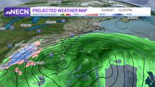
The next shot for a low pressure nearing New England is Sunday, as of now this low is staying south but may briefly brush the southern states Sunday afternoon into Monday morning.
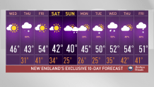
It’s too early to pin down the timing or type of precipitation, however, temperatures will trend more seasonable after a warm work week. Saturday and Sunday will see highs in the upper 30s to lower 40s. After that, another round of mild temperatures are ready to jump to the mid-40s to mid-50s slowly starting the following Monday and up to the end of the following work week.
