We started off the day with cloudy skies and a tranquil morning commute. This evening is not the same - we've been having more snow in the area that continues to push northeast.
Snowy Wednesday evening commute
It's been light to moderate for most with isolated spots getting heavier snow, but our totals are not adding too much. Our snow's been having a hard time sticking to the roads and sidewalks considering our changing sun angle, milder temperatures and the fact that our road temperatures have remained above freezing all day. But cold surfaces like car tops and grassy areas are already watching light accumulation, especially west where our snow began earlier.
The Massachusetts Department of Transportation had 894 pieces of equipment out during Wednesday evening's commute, with speed restrictions of 40 mph on the Mass. Pike on the New York border to Westfield. There were still 845 pieces of equipment on the roads as of 10:30 p.m.
Get Boston local news, weather forecasts, lifestyle and entertainment stories to your inbox. Sign up for NBC Boston’s newsletters.
Total snowfall amounts range from a dusting to an inch closer to the northern mountains, 2-3" with isolated 4" in the Berkshires and highest elevations, while the far southeast with 1-2." The snow exits before 11 p.m. and breaking clouds will allow for our lows to drop to the 20s and 30s overnight.
Warming temperatures Thursday
Weather Stories


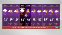
Our morning will be mostly bright with a mix of sun and clouds through the afternoon. Highs will remain in the upper 40s tomorrow, nearing the 50s from Connecticut to southeastern Massachusetts, and Friday will be another dry stretch with highs in the 40s. And while many thought we were ready to celebrate spring, winter is wrapping it up this weekend with a potentially strong system bringing plowable snow to the mountains and brief flurries for central/ southern New England.
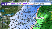
A First Alert for Saturday's storm
The forecast for this Saturday is still not fixed, it will likely change a bit more, but analyzing its current track, we will watch for the snowline advancing from the northwest of Vermont early in the morning to the south, southeast after sunset. A First Alert Stamp has been placed for Saturday as we continue to monitor the progress of this next system and the strong wind gusts it could bring to portions of New England. While Saturday will reach the low 40s during the day, we work our way into cooling Saturday evening towards Sunday, our highs Sunday will remain in the 30s and climb rapidly to the 50s for much of next week.
Remember our clocks spring forward one hour on Saturday night into Sunday, this will now bring us a sunrise at 7 a.m. on March 13, with the sun setting at 6:48 p.m. Stay tuned on NBC10 Boston and NECN as your First Alert Team keeps you updated.