
Forty-eight hours prior to the onset of any storm, there’s some degree of uncertainty – but some storms carry more uncertainty than others, and this weekend’s weather system is one of those more uncertain setups.
Some of the root of uncertainty stems from our First Alert Weather Team’s experience that an east wind off the ocean usually means a flip to either poorly accumulating snow, mix or rain, but this time that historical knowledge is juxtaposed with high-end computer guidance largely insisting heavy snow amounts in excess of six inches will spread to the coast.
Although we certainly trust our experience above all, we also are humble enough to continue evaluating the storm setup continuously before advertising any misleading information.
Get Boston local news, weather forecasts, lifestyle and entertainment stories to your inbox. Sign up for NBC Boston’s newsletters.
In the short-term, it’s all about the arrival of cold air, not the storm! A cold front crossing New England from northwest to southeast Thursday will take a relatively comfortable day with highs in the 40s for many under lots of clouds with a few light rain and snow showers, and turn the air decidedly more harsh by evening, as the northwest wind behind the cold front gusts to 35 mph, the temperature drops and wind chills reach the teens by late evening.
Overnight Thursday night through Friday morning, many communities will experience a wind chill in the single digits above zero – and even below zero in some of northern New England! Ample sunshine Friday won’t negate the cold air entirely, with high temperatures in the 30s for most and 20s north, then clouds arrive ahead of the incoming storm Saturday with chilly air continuing and a very light wind.
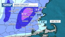
Snow totals this weekend in Mass., NH
While the onset of significant snow is expected late Saturday evening and overnight into Sunday, it’s worth noting a develop ocean breeze Saturday evening may carry some pockets of light snow or flurries into a few spots around southern New England by dinner.
As snow rates increase overnight Saturday night, plows and road treatments will be needed in many communities, continuing through Sunday morning before intensity wanes gradually but steadily during Sunday afternoon. While up to 12 inches of snow seems increasingly likely deep inland, the east wind gusting upwards of 40 mph Saturday overnight to Sunday is sure to carry warmth off the 44 degree ocean water, meaning a mostly rain event for Cape Cod and coastal communities in southern New England.
The more interesting zone to watch is from about 10 miles inland of the coast, through Interstate 95 and perhaps even to Interstate 495 in eastern Massachusetts, where the gusty east wind has the potential to carry warmth there, too, limiting snow amounts relative to the interior.
In northern New England, the potential for 4-8 inches exists outside of the far North Country where less moisture arrives, but the lingering uncertainty on northern New England snow hangs on how organized the bands of snow become.
Tuesday night storm could bring more snow
We’ll all see the weather quiet by late Sunday, with sunshine and seasonable air Monday, then a follow-up storm Tuesday night, which right now looks like it will bring snow to the mountains and a mix quickly changing to rain in southern New England, where Wednesday high temperatures behind that storm could reach 50 degrees!
Our First Alert Weather Team will continue to iron out the details and bring them to you without delay.


