
The first wave of precipitation is rolling into Western Massachusetts around 7 p.m. Sunday night. Although this isn’t the worst part of the storm, it will be producing a few slick spots in Central and Western New England through the night.
As a cold bubble of high pressure moves over a quiet and dry Northern Maine, however, the table is set for an unfolding ice event.
This sneaky high pressure system will supply the low level cold that will keep the temperatures subfreezing in many parts of Central and Western New England through the course of the storm. This thick, heavy air will be hard to scour out of the valleys and hollows without the aid of a strong wind (which isn’t in the forecast).
In the meantime, along the coast from Cape Ann through the North and South Shores and out to the Cape, it’s much ado about the rain. Temperatures here are much above freezing, and there aren’t any concerns for icing.
Continuous waves of precipitation through the day Monday will only add to the ice accumulation. Obviously, the more ice that accumulates, the better the chances for power outages and downed trees.
As a general rule, accumulations of over .4 to .5 inches tip the scale from isolated power outages to numerous or widespread. We’re expecting more isolated outages across the Merrimack Valley and Southern New Hampshire and scattered around Greater Worcester. Outages may be more numerous and widespread from Blandford, Mass., to Bennington, Vermont.
Travel on secondary roads will be difficult to treacherous in Western New England late Sunday night and Monday.
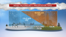
The schematic above shows the reason we’re not seeing all snow with this storm. An above-freezing layer of air from 5,000 to 7,000 feet is melting the snowflakes as they fall. Then the aforementioned high pressure system slips in the cold layer of air near the ground level to refreeze those drops into sleet – or freezing rain if the layer of cold is super shallow.
It’s a classic setup for ice here in New England, and this one is sure to crystalize the landscape for many away from the coast.
Farther north, the snow/ice line seems to waver around Route 2 in Northern New England throughout the course of Monday. Towns and cities north of that line should receive mostly snow, accumulating around 6 to 9 inches. Expect 3 to 6 inches south of that in the Lakes Region of New Hampshire and Maine, and 1 to 3 inches in Southern Maine, New Hampshire and Vermont.
The final leg of the storm comes on Tuesday, as the morning sees thawing and a turn to mostly rain across Southern New England. Perhaps a ray of sun is possible as a drying west wind takes over.
First Night in Boston should be the best in years with a steady breeze, dry conditions and temperatuers in the mid 30s.
Local
In-depth news coverage of the Greater Boston Area.


A final word: although this storm is not reminiscent of the crippling ice storms in 1998 and 2008, it has been a while since we’ve seen this kind of icing. Take it slow and easy Monday if you must travel.
