
The weather pattern remains similar day after day this week, as we're influenced by an upper level low rotating over Nova Scotia. This low swings in waves of light precipitation and clouds from the northeast. Also, we keep a gusty northwest wind around through midweek.
Highs on Tuesday will be slightly cooler in the 30s, but with the gusty wind, wind chills will be in the teens and 20s all afternoon. Waves of clouds move back in during the day from the northeast. And mountain flurries continue. With the northwest wind over the relatively warmer ocean water (40s), we have a chance for some ocean-effect showers or flurries across the outer Cape and Nantucket through the evening. Temperatures Tuesday night drop to below freezing, so watch again for ice redeveloping through the morning.
Wednesday and Thursday again brings us a gusty northwest wind and temps around 40 degrees. Wind chills will be around 30 through the days, with it feeling like the 20s up north. Clouds will again be around and a wave of a light wintry mix spins in from the northeast across northern New England and eastern Massachusetts both afternoons. A sprinkle or shower passes by eastern Massachusetts during the daytime, and flurries to mountain snow showers continue.
Get Boston local news, weather forecasts, lifestyle and entertainment stories to your inbox. Sign up for NBC Boston’s newsletters.
Friday is our best day of the week with sunshine and highs in the mid 40s as we prepare for a system this weekend.
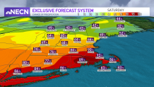
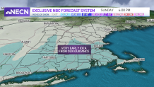
The system on Saturday into Sunday is still not a lock, but our exclusive NBC forecast system has a very high chance for precipitation in southern New England. The low pressure system heading across the Great Lakes will pass just to our south Saturday and this means we are in the cold section of this storm. The wind will be gusty from the northeast, and snow showers will be around.
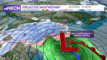
A couple inches of snow is likely for southern New England this weekend. The details are still coming together, so stay tuned to the First Alert weather team on timing, track and snowfall.
