
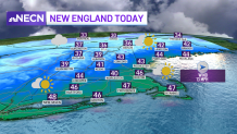
Clouds increase again as the afternoon goes on and we have milder temperatures in store Wednesday. Highs reach the 30s north, but low to mid 40s south.
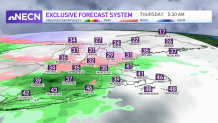
A warm front slowly approaches Wednesday night and will bring in more warmth as well as a wintry mix to rain across New England on Thursday. Overnight, scattered showers will mix with ice in higher elevations of New England for the predawn hours to around mid morning.
The front is slow to lift northward, so we wouldn’t be surprised if icy roads stick around through midday in the Worcester Hills, Berkshires, etc. Southern New England will see scattered showers for morning, drying in the afternoon. The wind picks up and gets quite gusty during the day -- around 30 mph from the southwest -- and this will usher in the warmer temps. Highs will be in the 40s north, and in the 50s to near 60 degrees far south.
Get Boston local news, weather forecasts, lifestyle and entertainment stories to your inbox. Sign up for NBC Boston’s newsletters.
Scattered showers move through with the cold front Thursday night into Friday morning and colder air rushes in. As this happens, the jet stream above us may help to increase our wind speed briefly in the evening until around midnight to 40 mph gusts, then the wind turns northwest around that time.
Temperatures continue to fall during the day on Friday with that northwest breeze, so highs will be in the low 40s early, falling to the 30s late afternoon. Saturday and Sunday is really when the colder air takes over. Highs only reach the 20s north to 30s south. At least both days look mostly dry.
Weather

The exception is in the mountains where upslope snow showers continue all weekend. And a weak system Saturday brings in a couple snow showers or flurries.
Another system moves through for Monday and this one is trending warmer, so mostly rain at this time. Stay tuned!
