Thursday marked the start of a noticeably different feeling in New England's weather: a milder feeling with the cold relaxing and temperatures set to warm daily until it challenges records this weekend.
For now, the absence of wind and the presence of sunshine is making the difference, with variable clouds still drifting over Cape Cod from time to time, but the solid deck of clouds and flurries of the last few days is gone even from the Cape.
Although high temperatures Thursday didn't exceed the lower to middle 40s, a quiet wind slowly shifts to blow from the south Thursday night into Friday, continuing the flow of new air that has produced high temperatures well into the 50s and 60s in the nation’s midsection this week.
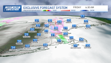
Often, the arrival of new, milder air comes with some increasing in atmospheric moisture and resulting clouds, and this time will be no different: clouds should fill in overnight Thursday night and when very light showers fall between 4 and 8 a.m. Friday morning, temperatures will be either side of the freezing mark, meaning we may see a couple of isolated slick spots in the early going Friday.
Get Boston local news, weather forecasts, lifestyle and entertainment stories to your inbox. Sign up for NBC Boston’s newsletters.
Given expected very light precipitation amounts, that’s unlikely to be a widespread issue and, regardless, temperatures quickly rebound from mid-morning onward, with abundant clouds breaking for some sun and a southerly wind nudging afternoon temperatures toward 50 degrees.
In fact, with Friday’s air delivering highs into the lower 50s in the Ohio Valley this week, it’s possible we break 50 by day’s end!
The milder trend won’t end there. By Saturday, highs should come close to our record high temperature of 60 degrees set on the date just one year ago.
Meanwhile, we’re heading into a few days with high tidal levels at our shorelines, thanks to Friday’s New Moon phase, and this should result in some splashover at the midday high tides Friday and Saturday, and perhaps some pockets of minor coastal flooding in typically vulnerable spots.
A cold front arrives Saturday evening and should spread scattered showers from west to east across New England late Saturday into Saturday night – in fact, with such mild air, a rumble of thunder isn’t likely but can’t entirely be ruled out in southern New England!
Regardless, the cold air behind that cold front is sluggish, so Sunday looks fair and still reaches near 50 degrees in southern New England, and 40s north.
Cooler air seeps into New England early next week at the same time the fast river of air high in the sky called the jet stream steers a disturbance close to New England. This disturbance, feeding off the temperature clash that's setting up, should strengthen to become a storm impacting the area Monday night through Tuesday, though right now the track, intensity and rain/snow line associated with that storm are far from determined.
Our exclusive First Alert 10-day forecast shows this mild spell isn’t the end of winter – another shot of colder-than-normal air arrives for the second half of next week.