Historically, odds are not in our favor for a White Christmas in southern New England. And this year again it looks like we miss out on the opportunity for snow.
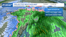
A late week storm system seemed promising a couple days ago (with a colder model output and snow around), but forecast models are now in agreement that warm air will be too much to overcome with a more northerly track.
WATCH ANYTIME FOR FREE
Stream NBC10 Boston news for free, 24/7, wherever you are. |
The storm system will strengthen and track far to the northwest of us, and there isn’t any apparent coastal low that develops to wrap in cold air. So rain is likely from Thursday afternoon through Friday across Boston and as far north as northern New England. Getting the mountains a bit sloppy with a mix, changing to rain on top of 1-2 feet of snow we had from the last storm.
Get updates on what's happening in Boston to your inbox. Sign up for our News Headlines newsletter.
The track can still change, and the timing may change as well, so keep checking back with our First Alert weather team this week. Winds will be strong from the southeast Friday and there may also be pockets of outages or damage. Plus tides are running astronomically higher due to the new moon.
We are monitoring some potential for minor coastal flooding and splashover. One interesting thing is as colder air rushes in behind this storm Christmas Eve, we may see a few snow showers around.
Daily forecast:
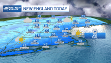
Today our highs will be in the upper 30s to low 40s with wind chills around 30 thanks to a westerly wind. Lows tonight drop to the 20s with again some icy spots. Snow continues across some ski areas and in Maine thanks to an upper level low. Adding a few more inches of snow today to the running weekend totals in northern Maine.


Monday through Wednesday highs stay in the upper 30s to low 40s. With a windy day Tuesday, wind chills will be in the 20s. The wind subsides for Wednesday, making this the best feeling day. Clouds will be around from time to time, but overall mostly clear through midweek.
Thursday and Friday brings in heavy rain, and gusty winds. Highs in the 40s Thursday, surge to near 60 by Friday. Then we cool off to about 30 degrees for Saturday and Sunday. Saturday will be windy with a few snow showers scattered around north and west. Christmas Day will be sunny, cold, and quiet.