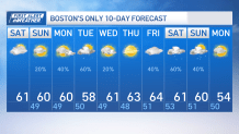
Today: Highs in the low 60s, increasing clouds, nw to west wind. Overnight: Lows in the upper to mid-40s. calm wind. Mostly cloudy. Sunday: Breaks of sun, variable skies PM, highs in the low 60s, n wind gusting 15-20 mph. Monday: variable skies, 20% chance of a quick shower, highs in the low 60s.
It’s a nice weekend across New England, as our low pressure system has pushed further south, we keep the showers mainly across coastal CT & RI. The rain shield is expected to move northeastward, with light rain mainly affecting areas south of a line from Hartford to Providence.
This light rain won't be a washout; instead, it's more of a nuisance. Dry weather is expected in the northeast of this line, with clouds increasing throughout the day. Temperatures will reach the upper 50s in Connecticut and western-central Massachusetts and the lower 60s in Rhode Island and eastern Massachusetts, slightly cooler than normal.
WATCH ANYTIME FOR FREE
Stream NBC10 Boston news for free, 24/7, wherever you are. |
Tonight and into Sunday, low pressure emerging off the mid-Atlantic coast will intensify as it moves eastward allowing for the immediate south coast, including the Cape and Islands, to experience a period of rain tonight into early Sunday.
The rain is expected to clear out early Sunday, with partial sunshine developing as the system departs. Breezy conditions are anticipated, especially around the Cape and Islands, with northerly wind gusts of 20 to 30 mph and even a few gusts near 35 mph on Nantucket. High temperatures should reach the upper 50s and lower 60s, which wouldn’t be too different from this afternoon.
Get updates on what's happening in Boston to your inbox. Sign up for our News Headlines newsletter.
The weather pattern will remain slightly unsettled with seasonable temperatures and more clouds than sun early next week. Showers are expected on Monday but primarily Tuesday, with a coastal low-pressure system potentially bringing additional shower chances on Tuesday.
The mid to upper 60s are likely towards the end of the week, signaling a warming trend. However, beyond the coming week, models suggest the potential for more unsettled weather the following weekend.