
After balmy highs in the 60s yesterday, winter is striking back. Two storm systems will race by in the next four days, with hand-wringing decisions on snowfall amounts and storm intensity.
Starting with the matter at hand, today’s isn’t worth getting worked up over. With temps in the mid and upper 30s, we’re in marginal snow territory. We’ll expect that showers will infiltrate much of the precipitation field in the early part of the storm, but as the system begins to move away later today, colder air will trickle in. It’s closer to sunset when we might see some minor accumulation on the grassy surfaces away from the coast. Count on colder temps overnight Monday to freeze things up, however.
Tuesday and Wednesday will be spent fine-tuning the forecast for Thursday. We’re not sleeping on the cold air either. It drops right out of Quebec - with arctic origins, mind you – by Wednesday morning. It is the real reason for the angst in the snowfall forecast. Too much cold pouring in will deflect the storm farther away from us. Just enough and we get white-washed. The intricate yin/yang of Nature never ceases…to amaze.
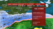
Some of our projections show us squarely in the 8-14” range areawide for the storm on Thursday. But the lone standout, our very own American model, shies away from the spotlight and just gives us a glancing shot at snow. It’s clearly locked into something, since it’s kept this idea afloat every 6 hours for the last two days. What is my feeling on this? That we won’t come away unscathed. Some accumulation is likely, but the idea of up to a foot (or slightly over) needs a better defense.
We’re on it every step of the way. Don’t miss the updates in the days ahead.