
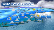
Our quiet stretch continues with a blend of sun and clouds and highs in the low 40s for many of us Wednesday afternoon. Wednesday night, we’ll drop into the 20s under partly cloudy skies and some snow showers in far northern New England.
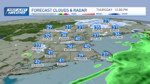
As a cold front sweeps through the region from northwest to southeast Thursday, scattered snow showers in northern and western New England through midday will drop a coating to a couple inches with elevations in the mountains and deliver a passing rain or snow shower elsewhere.
Get Boston local news, weather forecasts, lifestyle and entertainment stories to your inbox. Sign up for NBC Boston’s newsletters.
After reaching highs in the low 40s (30s north), noticeably colder air will arrive by Thursday evening. Despite full sunshine on Friday, we won’t get out of the low to mid 30s for highs (20s far north).
While plowable snow is likely for portions of New England, what remains uncertain is the exact track and strength of the storm center, which will play a critical role in determining the intensity of the snow and where the rain/snow line will set up. With water temperatures in the low to mid 40s and an east wind forecast for a time, even if we start as snow in eastern Massachusetts, a transition to rain seems probable, before flipping back to snow toward the tail end.
Snow forecast this weekend in Mass.
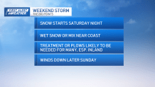
Saturday will be cold too, with increasing and thickening clouds ahead of a storm that will be advancing through the Mid-Atlantic by Saturday afternoon. For us here at home, areas of snow are likely to arrive sometime Saturday late evening and continue into Sunday.
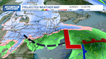
The wind doesn’t look too intense, but some gusts to 40 mph are possible at the coast.
The bottom line? While this doesn’t look like a blockbuster storm – it will bring the plows and crews out in many cities and towns.
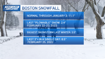
Boston snowfall: A look back
Another snowstorm next week?
Local
In-depth news coverage of the Greater Boston Area.


After things wind down later Sunday, quiet weather will greet us next week before the next system arrives. There are strong signals that a burst of wintry mix later Tuesday will change to rain as milder air works into the region with highs around 50 on Wednesday.
After that, we turn cooler again for the end of next week as seen in our exclusive 10-day forecast.
