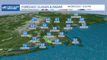
It took a while, but most of us regained mostly sunny, mostly smoke-free skies on Wednesday afternoon.
Pleasant dry air thanks to high pressure takes control for a brief time. Low temperatures will bottom out in the mid 50s to 60 degrees south, mid 40s to mid 50s across the North Country Wednesday night.
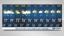
Thursday features increasing clouds and a building threat of showers as the day wears on, especially in the interior. High temperatures will again reach into the mid to upper 70s.
Get Boston local news, weather forecasts, lifestyle and entertainment stories to your inbox. Sign up for NBC Boston’s newsletters.
A warm front moving in from the south may bring a round of severe weather Thursday night into Friday morning across southern New England. The primary threats with these storms are expected to be damaging winds and small hail.
The threat of a spin-up isn’t totally out of the question. A cold front will cross the region on Friday, triggering showers and thunderstorms. Storms may become strong to severe across Maine. Highs will be in the upper 70s to low 80s.
Looking ahead to the weekend, a pleasant and dry stretch of weather is on tap across New England. Generally crisp and cool conditions will dominate the region, with low dew points and highs in the low 70s. It will almost feel like a taste of fall.
A warm front will nose into southern New England on Sunday, resulting in some showers in our First Alert 10-Day Forecast.