
What a start to spring, the first Saturday of spring started wintry, now wet (for most). Wind gusts range from 25 to 40 mph tonight, with higher gusts near 55 mph along the Southshore and the Cape.
The heaviest rain tapered off between 8-9 pm. Snow will move out for Southern New Hampshire around midnight, but ski country could continue accumulating snow for the higher elevations through Sunday.
As of 8:30p.m. on Saturday, more than 39,000 customers were without power in New Hampshire.
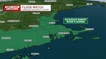
See all the weather alerts here.
Get Boston local news, weather forecasts, lifestyle and entertainment stories to your inbox. Sign up for NBC Boston’s newsletters.
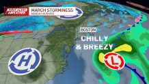
Locations closer to the coast won’t shake lingering clouds on Sunday with slow-to-rise highs in the upper 30s and low 40s. Another round of strong wind on Monday, resulting in wind chills in the low teens to start the week.
On-and-off rain returns from Tuesday through Friday. Temperatures gradually climb back to the low 50s by the end of the week.
Looking ahead, Easter weekend appears promising with highs in the mid to upper 50s, along with sunny and dry conditions – at least for now.
Stay tuned for further updates from the NBC 10 Weather team as the weekend approaches.
Be prepared for your day and week ahead. Sign up for our weather newsletter.
