
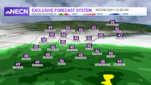
Clouds are rolling in from the southwest as our first of two storm systems affects us for midweek.
Heavy rains on Wednesday
Our first storm system is now across the southern U.S. and has been responsible for some severe storms and tornadoes today. The severe weather threat remains across the southeastern U.S. tomorrow too, not for here. We are positioned on the northern edge of rain in southern New England as the low heads offshore tomorrow morning, so prepare for some steady rain from morning through afternoon in Boston. The rain chance stops abruptly across southern Vermont, New Hampshire and Maine and northern New England remains dry.
Get Boston local news, weather forecasts, lifestyle and entertainment stories to your inbox. Sign up for NBC Boston’s newsletters.
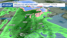
More rain, thunderstorms possible late Thursday
Another wave of low pressure moves through all of New England Thursday, into Friday. Late Thursday, we may see a couple thunderstorms around. High terrain in northern New England will see a wintry mix and light snow to then rain, and heavy rain for everywhere else south. Highs will be cooler in the 40s. After this heavy rain and around 1-2” of rainfall accumulation, our temps warm up a bit late Friday to the 60s.
While the heaviest rain moves out in the morning, there may be some instability showers in the afternoon. More highs around 60 degrees are anticipated both days this weekend but it won’t be completely dry. A cool pool of air aloft will keep daytime pop up showers around from time to time, mainly Saturday.
Next week our forecast has the potential for 70 degrees as a large warm up moves in. At the coast and in Boston we may stay just shy of the 70 degrees mark thanks to a sea breeze.
