We’ve seen a lot of frosty and cold mornings with seasonably cool days to start the month of November, but now we’re about to take a small break from reality.
Much of New England will see lots of sunshine and unseasonably warm temperatures Tuesday afternoon with highs reaching the 60s! A weak cold front will be sliding through northern-most areas Tuesday afternoon, so we’ll be seeing a bit more in the way of clouds there, but it’ll still be mild with highs in the mid to upper 50s.
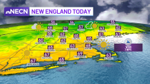
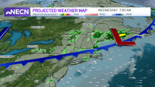
Overnight, the cold front slides through the region, bringing widely scattered showers and sprinkles through the early morning hours. Lows will drop into the 40s south, low 40s in much of northern New England, and low to mid 30s in far northern Maine.
Get Boston local news, weather forecasts, lifestyle and entertainment stories to your inbox. Sign up for NBC Boston’s newsletters.
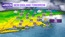
After a few lingering sprinkles and showers early Wednesday, we’ll see clouds clearing into the afternoon with temperatures still on the mild side. Highs reach the low 60s across far southern New England and upper 50s in the rest of the area. It will be in the mid 50s in central New England and low to mid 50s across the North Country.
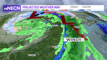
Thursday will feature a close to average day across the region with clouds on the increase, then our attention will focus on a system approaching from the west which will bring rain and wind during the day Friday and into Friday night.
Our biggest concern will be locally heavy rain during the afternoon and evening along with gusty winds, especially along the coast. Rain amounts look to be between 1 to 1.5 inches and winds may gust over 40 mph. Our weather team has issued a First Alert for Friday and will continue to keep you updated as we get closer to the event!