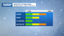
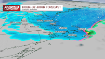
After 6 a.m., the heavy snowfall will ease up as warmer air pushes in and dry air moves in. This will slow down the snow briefly.
However, in regions northwest of Interstate 95, there will still be some lighter snow on Sunday morning. Later in the morning to early afternoon, especially in eastern Massachusetts, there will be another round of moderate to heavy snow.

As this system strengthens and exits, it will pull winds in from the northwest, bringing widespread cold and that second chance for bursts of snow, even along the coast.
Get Boston local news, weather forecasts, lifestyle and entertainment stories to your inbox. Sign up for NBC Boston’s newsletters.
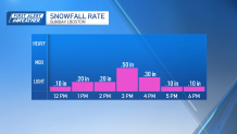
Timing for the snow to pick back up will be between 11 a.m. and 4 p.m.

As temperatures drop rapidly in the afternoon, and wet snow on roads could freeze, making travel risky. Warnings for winter storms and advisories for winter weather are in place for most areas except the Cape and Islands.
Local
In-depth news coverage of the Greater Boston Area.
Snow accumulation the last 24 hours, current snow totals
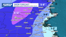
Snowfall estimates for inland areas are from 8 to 12 inches in places like the Berkshires and Worcester Hills. The gradient drops off quickly, for areas closer to the coast 1 to 3 inches are likely and the best bet for accumulation along the coast will be once the winds shift to come in from the northwest.

Sunday snowfall rate

Monday morning, temperatures take a tumble to the upper teens and low 20s, bringing in the chance for refreezing any water that is on surfaces or roadways. Highs on Monday rise to the mid and upper 30s. Our next system comes in Tuesday evening through Wednesday night. A strong system will head our way bringing gusting wind, heavy rain, and the potential for river and stream flooding.


