
A First Alert continues for the northern half of New England for Saturday as we await what will amount to a significant winter storm in Ski Country. While this is great news for skiers, winter storm driving conditions are anticipated throughout the day there.
But first, we start with a quiet Friday – the dew point temperature, or measure of the amount of moisture in the air, has dropped near and below zero, indicating exceptionally dry air typical of a mid-winter day.
Although the stronger sun angle – now equivalent to September sun – will help to bump Friday high temperatures above 40 degrees, New Englanders will still experience a few static electric shocks, chapped lips and dry skin like we would in this dry air mid-winter, so hydration is important.
Of course, wintry air doesn’t stop some of the typical spring seasonal phenomenon that already have begun: pollen count will remain moderate and brush fire danger will be moderate, as well. Sun gives way to increasing late day clouds and after midnight, light snow and rain moves in.
Get Boston local news, weather forecasts, lifestyle and entertainment stories to your inbox. Sign up for NBC Boston’s newsletters.
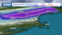
Snow forecast for NH, Maine and Vermont
Saturday will dawn with snow falling for much of New England north of the Massachusetts Turnpike, though a change to rain will be quickly progressing north between 7 and 9 a.m., moving through southern New Hampshire by that point after dropping a coating to two inches of snow in central and northern Massachusetts, and 2-4 inches in southern New Hampshire.
Winter storm warnings and watches are already in effect for much of northern New England from Saturday through Sunday morning.
Morning precipitation will remain relatively light even after the change to rain, but heavy rain is expected during the afternoon and evening for central and southern New England, while snow continues to fly in the mountains.
Snowstorm in Ski Country, power outages possible
Local
In-depth news coverage of the Greater Boston Area.


If you're headed to Ski Country, it’s best to leave Friday evening or wait until Saturday night or Sunday morning, as travel in the North Country otherwise will be in a snowstorm and should include a winter driving kit with blanket, shovel, and sand.
Power outages also are possible by Saturday afternoon and evening across the heavy snow zones, where snow consistency won’t necessarily be sloppy, but there will be 8-16 inches of it, which will put strain on limbs and power lines.
Flood watches in effect for southern New England
Further south, the 1.5 to 2 inches of rain won’t cause widespread flooding, but certainly will put big puddles on the roads and highways in the latter half of the day, especially, slowing travel for all.
By Sunday morning, that rainwater runs into rivers and spots of minor river flooding are possible, with the Wood and Pawtuxet rivers in Rhode Island perhaps reaching moderate flood stage in a winter and spring that has delivered frequent flooding to those river basins. A flood watch is in effect for much of southern New England from Saturday morning through Saturday night.
Snow and rain is expected to end overnight Saturday night, leaving a dry day but a cold northerly breeze Sunday with wind chill values topping out around 30 degrees – though the weather should be splendid to enjoy the fresh snow on the ski slopes.
What's next?
Cool, wintry-feeling air lingers through a dry Monday, moderating only slightly by Tuesday, but by midweek the shower chance rises as the cold begins to break down and clashes with incoming milder air that, as of right now, looks to deliver a milder and quieter weekend next weekend for Easter Sunday.
