
Outdoor plans are a go this evening, but bundle up because if you’re staying up till late our temperatures will turn nippy.
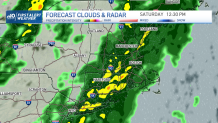
Clouds will begin to increase their coverage and widen across New England early tomorrow bringing showers before 9 a.m. west of Hartford, CT and into Pittsfield, MA. Those showers will expand into eastern MA by midday and will bring embedded downpours across southern New England. Highs will rise to the upper 50s to near 60 with moist conditions.
STAY IN THE KNOW
Watch NBC10 Boston news for free, 24/7, wherever you are. |
|
Get Boston local news, weather forecasts, lifestyle and entertainment stories to your inbox. Sign up for NBC Boston’s newsletters. |
The rain and showers will have a break after sunset while a second but brief round will produce lighter rain late evening. Skies will begin to clear rapidly on Saturday night as the cold front pushes through dropping temperatures and drying the atmosphere.
329 medal events. 32 sports. Endless drama. Catch all the action at the Paris Olympics. Sign up for our free Olympics Headlines newsletter.
Sunday will feature a bright start to the day with increasing clouds late afternoon and cool temperatures. Highs on Sunday drop to the 40s and as the wind remains somewhat breezy we’ll have chills in the 30s one more time, similar to what we experienced just yesterday. Monday brings another afternoon with a mix of sun & clouds, highs in the 40s and lighter wind.
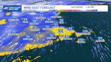
The stage will remain set up for our next frontal boundary pushing in milder air again and showers by Tuesday into Wednesday. Winds this time will likely gust below 40 mph.


A more chilly weather pattern will fill in late week, dropping temperatures to the 30s on Friday afternoon, lows will dip into the 20s.
With this colder air and with possible moisture by the end of the following weekend, we may the chance for some snow in southern New England.
Stay tuned, NBC10 Boston’s & NECN First Alert Team will keep you updated.
