
A storm is slamming New England Monday morning, and the worst of it is sweeping through during the first half of the day.
A flash flood warning is in place for parts of western Maine until 2 p.m. and in southern Connecticut until 10:30 a.m. See all weather alerts in your area here, and check school closings here.
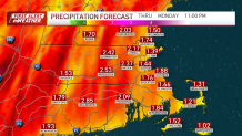
Downpours will consolidate in a grand finale of wind and rain toward noontime. In the meantime, gusts will hammer us from the south/southeast as occasional burst of heavy rain zip by on a fast-moving jet stream in the middle atmosphere.
This is precisely how we get our strong winds and intense rain. Winds are whipping at over 100 miles per hour about 5,000 feet up, and as the storm taps into this wind field, it produces our gusts here at ground level.
Get Boston local news, weather forecasts, lifestyle and entertainment stories to your inbox. Sign up for NBC Boston’s newsletters.
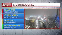
In any event, prepare for scattered power outages amidst this strong wind. Flooding of basements, intersections and small streams is also possible in any intense rain through midday. Larger stem rivers may flood starting tomorrow and through midweek.
As the core of strong winds moves away in the middle atmosphere, we'll see a sharp drop in the wind intensity this afternoon. As a result, the evening drive is not as white-knuckled as the morning commute. Temperatures will slide from these unheard of 60s to the 50s and eventually the 40s Monday night.
Rest of the week looks tame compared to Monday. A few showers are still possible Tuesday, along with cooler temperatures. A fine stretch of quiet, cool, bright weather will start on Friday and roll right through Christmas. It's an extended travel gift from Mother Nature.
Local
In-depth news coverage of the Greater Boston Area.


Updates throughout the day on all our platforms. Stay safe!
